
Rupert Holmes on the future of chartplotters and onboard displays, which are developing in several directions from tablets to multifunction displays

Multifunction displays for navigation, instrument data, radar, AIS, and even watching Netflix, continue to evolve, especially at the high end of the market. While early units were hampered by a lack of processing power, they’re now much improved.
B&G’s latest Zeus S MFD, launched at Boot Düsseldorf, is the company’s second device to use Android, following the large format Nemesis instrument display. This has helped create a more intuitive look, feel and set up despite the greater number of sophisticated features than earlier models.

Processors are also faster and memory is larger, which speeds response times, especially when charts are redrawn while panning or scrolling. Separate racing and cruising modes further simplify menu structures.
In addition, waypoint up and wind up chart displays are now possible, as well as the familiar north up and head up options. The shading of laylines also looks to be more informative – instead of simply showing the extremes of the cone, the areas close to the average wind direction are darker. And there’s a basic route planning function, but this is based on measured wind and tide data, so is of limited use in its current form.
MOB functionality is also improved. In addition to showing bearing and distance to the location of the incident, the unit also displays instructions for making a mayday call.
This may sound like a small point, but the ability to assign a relatively inexperienced crewmember to the VHF in a time of crisis, leaving the more experienced sailors to carry out the rescue procedure, can be an enormous help.

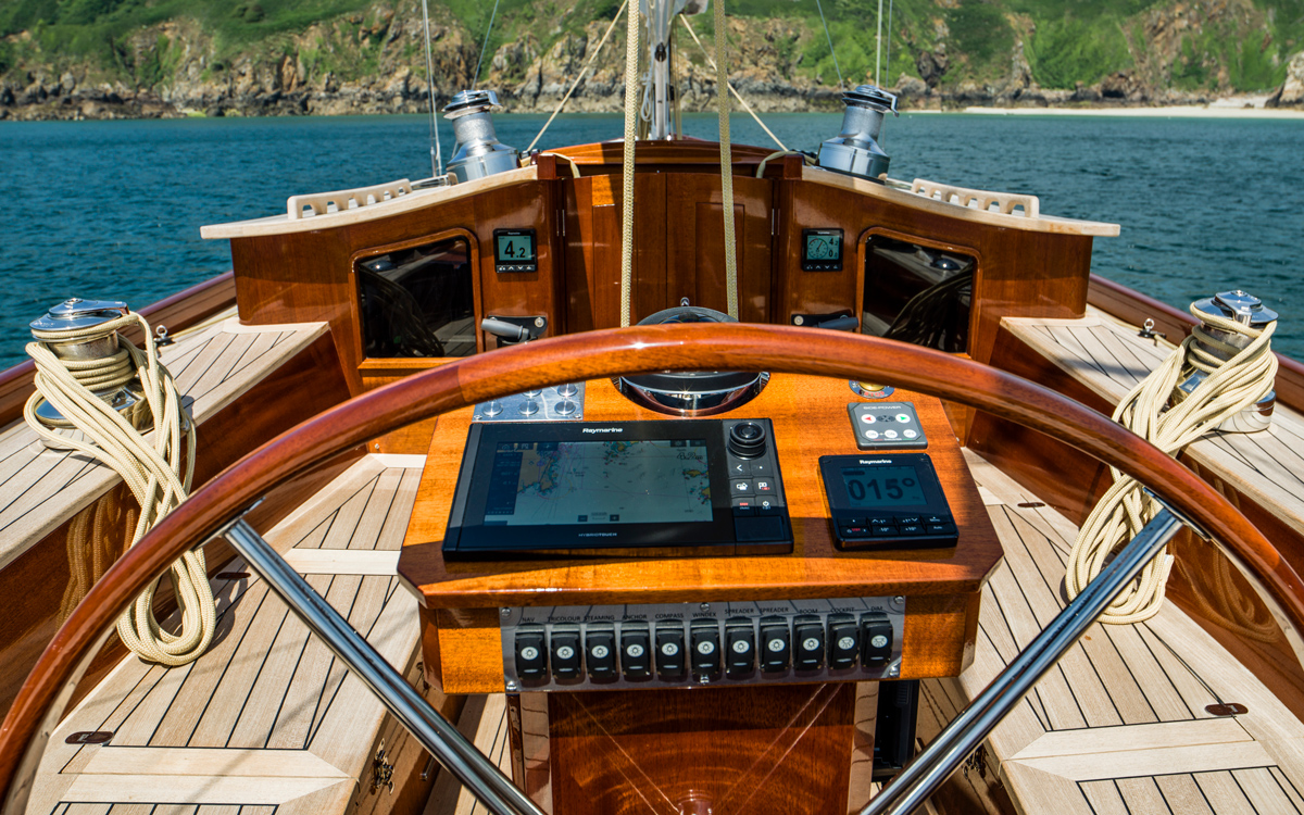
Raymarine also chose Düsseldorf to launch its new generation Axiom 2 Pro MFD. This too benefits from a faster processor, more memory and improved touch screen. The unit retains hybrid functionality that allows it to be controlled by hard keys or screen and adds features such as user-customisable hard buttons with potential functions including pilot control.
Screen glare and sparkle is reduced, while colours are brighter and a better oleophobic coating improves touch control when wet.
There’s a long-awaited ambient light sensor for automatic back lighting, although day/night/extra dark modes are retained, as is manual lighting adjustment. In addition there’s a micro HDMI and audio output for use with apps like Netflix and Spotify.
As with existing Raymarine devices, PredictWind’s offshore app can be downloaded to enable the MFD to be used for weather routing, including departure planning.

Orca was created to challenge the idea that navigation displays have to be single-use devices
A tablet future
Two notable startups are convinced conventional MFDs will cease to be the best option for most of us in the future. Instead they are focussed on features established companies have been slow to incorporate, particularly incorporating routing and weather information with charting. And at prices that, in some cases, are a whole order of magnitude lower.
Orca was founded by a pair of employees from a big marine electronics firm, with the aim of making high-end navigation experiences accessible and understandable. It runs on Android and iOS apps and is free to use when mobile phone data is available, while downloading charts requires a paid subscription.
“We want to prove you can have an experience that until now has been reserved for much more expensive chartplotters,” co-founder Jorge Sevillano told me. “We also want to challenge the idea that navigation displays have to be single-use devices.”
Article continues below…

Best personal locator beacons and AIS units 2026: 16 top options for boating
Locating a crew member who has fallen overboard in anything other than the most benign of conditions is a huge…
Best chartplotter: 6 great options from marine MFDs to tablets
Not sure where to start looking for a chartplotter or MFD? The terms ‘chartplotter’ and ‘MFD’ are broadly used interchangeably,…
Small motorboats and RIBs were expected to form the core client base, but knowledgeable sailors seeking a feature-rich experience quickly became the largest user group. This led to incorporating routing for sailing vessels, using weather data from sources including NOAA, Meteo France and the MetOffice, along with the vessel’s own polars, or those of a similar yacht. The system also enables autopilots to be operated via mobile devices, including Apple watches.
Despite its software-first approach, Orca recognised from the outset two items of hardware were also necessary. The Orca Core is a wifi repeater for instrument data such as wind, depth and log, with internal high accuracy GPS receiver, nine-axis sensor including compass and data logging function. In effect it’s a Linux computer in a black box, so functionality can be unlocked at a later date.
Orca has also developed 10in Android tablets, unveiling a second generation model at Düsseldorf. The touch screen is specified to be on a par with dedicated chartplotters in wet and salty conditions, while there are also customisable hard buttons for instant access to frequently-used functions. Split screen modes enable part of the screen to be used for instrument data and the rest for charting.
When used in a mast or helm mount the display is as bright and robust as an MFD. Yet after sailing you can take it below for passage planning, to watch a film, or pair it with a keyboard to catch up on social media and work.

Savvy Navvy describes itself as ‘like Google Maps for boats’
Savvy-Navvy
Meanwhile, Savvy-Navvy founder Jelte Liebrand, an ex-Google engineer, aims to make the process of passage planning, navigation and monitoring weather as quick and simple as possible.
It’s an appealing concept, even if early iterations were insufficiently sophisticated to deliver when complex tides or navigation was involved. However, there has been a great deal of development. Depending on the level of subscription, either the GFS weather model, or the Meteomatics Mix that combines ECMWF data with 25 other models, is used. It’s an excellent option for an instant result when weather patterns are fairly stable, but doesn’t offer the level of insight that can be gleaned through laboriously checking out different models. To keep things simple only very basic data about your boat is used for routing and there are no options to load your own polars, nor to use those of a similar vessel.

Sailgrib WR
SailGrib WR
SailGrib WR, an Android app created by French developer Henri Laurent, available for a one-off fee of £84, remains my favourite tool for easy routing and charting. It takes time to get accustomed to the software and its extensive capabilities, but it’s then much quicker and more intuitive to use than PC-based systems.
You can choose from two dozen weather models, including ECMWF 0.4˚ and 1.0˚ outputs, plus Arome’s high-resolution data. Basic tide and current data is available free, with high-resolution files available as in-app purchases, and a variety of charts, including Navionics, can be integrated.
I used it for well over 2,000 miles of sailing last year, including deliveries between the Atlantic coast of France and the Solent, plus the La Trinité-Cowes and Cowes-St Malo races. It’s sufficiently powerful that many in the French offshore racing community use SaibGrib WR in preference to significantly more expensive PC-based solutions.
Importantly, it shows isochrones – lines that show the various positions the boat could reach at different times. If these are fairly straight and parallel it indicates the optimal course is not critical and there’s latitude to stray either side of it without extending the length of the passage. Weather 4D is a similar offering for iOS users.
The ultimate solution for onboard displays of course varies with different uses and budgets. A useful tool for a RIB ride from Cowes to Poole might look very different to one for a 300-mile passage from the UK’s east coast to north Brittany in a 40ft yacht.
Combining routing with charting makes for a potentially powerful system, but it’s important to recognise the output of every routing algorithm requires critical analysis to ensure it won’t place the boat closer to dangers, whether shoal water or shipping channels, than good seamanship would demand.
 If you enjoyed this….
Yachting World is the world’s leading magazine for bluewater cruisers and offshore sailors. Every month we have inspirational adventures and practical features to help you realise your sailing dreams.Build your knowledge with a subscription delivered to your door. See our latest offers and save at least 30% off the cover price.