
Ocean racer Nick Moloney returned to the deep south with a memorable voyage sailing to Antarctica on the 66ft ketch Ocean Tramp

The dense silence is broken only by the sound of snowflakes landing on my protective clothing, as my eyes struggle to adjust to the landscape that surrounds me. It is so beautiful, so diverse, and so beyond anything that I have ever previously seen. I am standing on the top of a small, low lying, snow capped island that is skirted by open ocean, islands and wide bays.
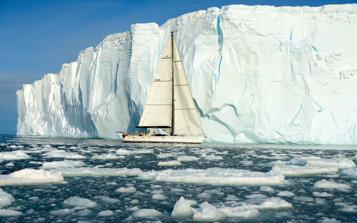
Looking seaward, there is a cluster of huge icebergs that stretch north towards a horizon that’s now entering twilight. Below me lie wooden rowing boats, abandoned in 1915 and preserved under snow for the majority of the year but, for now, clearly exposed. These are small iceboats that originally serviced the whaling ship Governoren, which lies in the backdrop, wrecked in the shallows of Enterprise Island. Our yacht is tied alongside her decaying steel hull.
The Governoren’s fate was determined nine days after Shackleton’s famed Endurance was wrecked, when she was performing her duties around Foyn Harbour as a floating whaling factory. On this particular voyage, the crew threw a party, a lamp was knocked from a table and the ship caught fire. The Governoren was full of whale oil and the fire quickly grew out of control. The captain grounded the ship and all 85 crew escaped without injury, to be later rescued by another whaling vessel.
I’m standing in a place that I once promised myself to do all that I could to visit: I am in Antarctica.

Ocean Tramp moored to the wreck of the Governoren at Foyn Harbour, Enterprise Island. Photo: Caesar Schinas
Antarctica is the coldest, windiest and driest continent on Earth and these elements create amazingly diverse snow and ice formations. White, soft snow dunes pile in one corner, while other edges are marked by an array of sharp peaks and ridges, so steep that the ice and snow cannot settle, revealing stark black unburied rock. The land evokes a sense of remoteness, of emptiness, and a deep respect that is difficult to explain. I am a well-travelled man, yet this was a place like no other.
As a seafarer, I have seen many contrasting seascapes and landscapes among my several passages around the world, but nothing as diverse or as dramatic as the relatively short transition from the islands of the South Shetlands to the Antarctic Peninsula.
My preparation for this trip began many months prior, and was an agonising build up to a voyage that I was simply never sure would actually happen. The core of this journey would be in February 2020, the month that is deemed the closing window of the Antarctic summer season and the end to most expeditions to the region. As with many projects and key moments in my life, I was relying on nature and the elements to align.
Article continues below…
Sailing Antarctica: Record-breaking voyage around the southern continent
Many believe number seven to be lucky. The seventh day of February proved to be just that. It’s seven weeks…

The adventures of Infinity: Sailing to Antarctica on a 120ft handmade ketch
“When I say ‘Jump!’ y’all say ‘How high?’. If y’all don’t want to say ‘How high?’ you can pack your…
My first real contact with those who I was to share this experience with was in Punta Arenas, a city near the tip of Chile’s southernmost Patagonia region. It is on the Strait of Magellan, which connects the Atlantic and Pacific oceans. We would fly from Punta Arenas to King George Island, but not before ‘kissing the toe’ at the Ferdinand Magellan statue in memory of this great explorer. This tradition is said to assure your return to Punta Arenas, to ensure safe onward passage, and even to cure seasickness.
In a hotel in town we had our safety briefing and picked up the sanitised footwear that could only be worn on Antarctic landings to protect the natural ecosystem. We then entered a standby period, where we basically sat by our phones waiting for the call that a weather window had opened for long enough that we could fly the 75 minutes from Punta Arenas to land on Antarctica’s most northern airport, a gravel strip on Fildes Peninsula.
Besides a modified aircraft parked on the stones and a few lights along the levelled landing strip, it bore no other resemblance to an airport whatsoever. There were just 20 passengers on our flight, seven of whom were heading to the same vessel as me. The remainder was made up of researchers, scientists and a photographic tour that was mapping whale sightings.

We landed at King George Island at sunset. My first impressions were of the shocking cold, and the most amazing light piercing the cleanest of air. While I was gathering my emotions, a sudden pat on my back broke my reverie.
It was that of my dear friend, and legendary Irish yachtsman, Damian Foxall. We hugged and laughed at the fact that we were about to share this moment, almost 20 years after we had started The Race together onboard the maxi catamaran Playstation.
Friends reunited
Damian was skippering the 66ft ketch Ocean Tramp. My time with him and his team would be the final phase of their three month immersion in the Antarctic region, working with scientists, marine biologists, animal and landscape photographers, writers and nature lovers. Damian was supported by his wife Lucy, and Niall MacAllister, who are both marine biologists.
Each individual in our group had a different purpose for being there, but were united by a common goal to commemorate the 200th year anniversary of the discovery of Antarctica, an epic story of bravery and pioneering. The first credited discovery of mainland Antarctica is not free of controversy.
Given that three of the four in command of our vessel are from Ireland, there was an understandable focus on recognising the role that the Irish explorer Edward Bransfield played in this particular page of history.

Author Nick Moloney stands a night watch at the helm
Bransfield logged his first recorded sighting of mainland Antarctica, a sector now known as the Trinity Peninsula, as “Such was the discovery of Antarctica” on 30 January, 1820, and submitted it to Admiralty on his next port arrival in Valparaiso, Chile.
Unbeknown to Bransfield and his crew, on 28 January, a mere two days earlier, Russian explorer Fabian Gottlieb von Bellingshausen had logged the coordinates of a possible land sighting, as ‘an icy shoreline’. Later, on the basis of the coordinates noted in Bellingshausen’s logbooks, he was ultimately credited with the continent’s mainland discovery, an area now known to be part of East Antarctica.
From King George Island we mapped a course around storms, weather systems and wind directions to visit and explore the South Shetland island cluster prior to crossing the Bransfield Strait to the Antarctic Peninsula. The following days rewarded us with endless encounters with wildlife, navigating waters with little datum records, and landing on some of the most remote earth on this planet. The sense of remoteness was made clear by the complete lack of other human interaction or even vessel sightings.

Intact whale skeletons litter the beaches of Goudier Island
Man’s impact
The South Shetland Islands are layered in base colours: black volcanic terrain that is the foundation of ice capped mountains, peaks of bright white ice, with deep blue edges. The beaches appear to be moving from a distance, as waves of grey extend from the base of the hills into the sea. This, of course, is the march of the penguins.
Although not threatened by, but certainly curious of, our presence, seals cruised the shallows of the shoreline while penguins sought the open water. Both animals were searching for their next meal. Unfortunately for one, that meal is the other. Leopard seals snarled as we landed ashore on the Shetlands and dragged our dinghy across the shoals. This is their world, not ours.
A visit to Whalers Bay on Deception Island offered a stark reminder of the devastating toll that whaling has had on the region. Deception Island is now a scientific outpost and Whalers Bay is a protected cove that is the caldera of an active volcano. Landing on the beaches, where the thermal heat of the volcanic activity causes steam to rise through the gravel surface, we found ourselves surrounded by the broken skeletons of industrial buildings and large holding tanks.

Damian Foxall reviews the charts with the expedition crew
The remains of the original whaling station, like the wreck of the Governoren, are ghostly echoes of the past two centuries of human encroachment. It is a period that resulted in the decimation of virtually all of the world’s whale species, most of which are still at a small fraction of their pre-whaling levels.
Fortunately there are many efforts in motion in the fight against illegal whaling and the protection of wildlife and resources in the region. Part of the reason for our journey south was to support a collaboration between my watch sponsor, Delma, and The Antarctic and Southern Ocean Coalition (ASOC) in their mission to protect the wilderness and wildlife.

Foxall at Ocean Tramp’s helm station
It is approximately a two-day sail across the Bransfield Strait from the South Shetland Islands to the deep Antarctic fringes, and we sought shelter from an isolated gale at Trinity Island before pressing on. Sheltering in a yacht near glaciers to find protection from strong winds takes a different set of knowledge and skills to any other situation I have exposed myself to at sea.
I quickly realised the value of land anchor lines on deck spools and was genuinely surprised by the load generated by the force of the wind transferred onto the mooring lines. The process of anchoring and running land fixed lines in strong winds is potentially one of the most dangerous tasks in this environment, and the cold and rapidly changing conditions call for heightened safety considerations.

Paradise Bay
Anchoring near the point where glaciers meet the sea also provides plenty of time to contemplate the unpredictable nature of these huge blue pillars. The columns are unstable, their fragility regularly demonstrated by frequent collapses of parts of the wall. This is calving, and it sends a loud roar that breaks through even the howling winds, followed by the thunderous entry of tonnes of ice breaking the water’s surface.
When a glacier calves and the ice falls into the sea, a wave is forced outwards. I frequently lay in my bunk at night, woken by the sound of falling ice before feeling the boat rocking as the plunge wave rolled beneath our hull. That ice then breaks up into smaller pieces and begins to drift.
These chunks of ice would make their way past Ocean Tramp, often scraping along the waterline of our hull. I had a small porthole next to my bunk and among my fondest memories is watching this beautiful sight as growlers scraped past my window in the night.

Mirror-calm conditions and growlers in Paradise Bay
Leaving Trinity Island in strong but abating winds, we sailed past an iceberg aground in 40m of water. The further south we travelled, the more intense the weight of remoteness became. The most common word used to describe the environment was ‘wilderness’, by definition ‘uncultivated, uninhabited, and inhospitable’. Antarctica is pure wilderness, by every measure and in every sense.
To reach Antarctica held deep emotion for me, a feeling that I’d honoured a personal promise to myself. On my previous passages around Cape Horn, I’d often looked towards the south and longed to one day connect with the nature and elements that make Antarctica so unique.
The Antarctic region is a sanctuary, home to its native wildlife. We are guests there and privileged to witness the individual adaptation of each species, and their pure fight for survival. I have never before felt more responsible for my actions than during my time in Antarctica. My conscience has an overwhelming sense that this place should be simply left alone, yet in my heart I have a strong sense that only through knowledge and experience comes a strong will to protect.

Spools of hefty land mooring lines used to secure Ocean Tramp
Exploring the peninsula
The passage between the snow covered islands in the Gerlache Strait is littered with varying sized icebergs. Those with low, flat, horizontal sections generally offered a resting spot for a lone fur seal. While the South Shetland Islands are home to huge penguin colonies, most of the Peninsula coast is steep and penguin numbers thin out to small groups.
Paradise Harbour was a true highlight. The bay is a wide expanse of calm water in a naturally sheltered and protected cove. It is a place of abundant wildlife and thick silence. Mirror reflections of snow covered hills lie on the still water surface, surrounded by the most diverse range of icebergs sculptured by the elements. It is quite possibly the wildest, yet most peaceful place that I have ever visited. In this bay I felt strangely embraced by Antarctica.
From Paradise Harbour we headed to Port Lockroy, a small natural harbour on Goudier Island. During World War II, the British military established Station A here and the outpost was a research station until 1962. Today, the United Kingdom Antarctic Heritage Trust manage the facility which also functions as a museum.

Posting letters home from Port Lockroy
We were the only visitors that day, and spent time chatting to those who had manned the station over the last four months. I must admit that I was envious of their experience and opportunity to live in this amazing place, to experience the season shifts and the cycle of receding and returning snow.
On Goudier Island we came across skeletal whale remains along the shoreline. It was here during Zodiac transfers from our yacht to shore that a leopard seal bit into, and deflated, the stern section of our semi-inflatable. It was also here that we realised that the next few days offered the only foreseeable weather window between strong southern ocean storms in the Drake Passage, the gap we needed to make safe passage to the Falklands.
From Port Lockroy we headed to the famous Lemaire Channel. The Lemaire Channel is also known as ‘Kodak Gap’ for its photo opportunities, making it a must-visit spot for cruise ships. While I had heard many stories of cruise ship encounters tarnishing the connection with nature in Antarctica, we had been lucky. For most of our time in the South we were alone, and fortunately remained so in Lemaire.

Heading into the Lemaire Channel
The Lemaire Channel is genuinely breathtaking. It is a still body of water, protected by the sheer rise of the Kiev Peninsula and Booth Island on either side. A mass of icebergs densely fill the channel, making a passage through often difficult, even impossible.
This is where we encountered the most dense ice flows and got a taste for what the area must be like in winter months. From the Lemaire Channel, we began our departure from the peninsula.

The rugged mountains of Anvers Island
As I have done so many times, I found myself on deck for long periods simply staring at the landscape falling away in the distance. I, for one, experienced genuine heartache as we set sail away from Antarctica. My connection to the ‘final continent’ was very brief but my memories are precious and cherished.
Exiting Antarctica was rough going. Seasickness overwhelmed several on board, and going into our first night in open ocean we were continually faced with enormous ice formations drifting in the currents. The 850-mile sail across Drake Passage, from Lemaire Channel to Stanley in the Falkland Islands, took around five days.

Approaching the Falklands. “It was a long journey but passagemaking without racing is a rare treat for me, particularly not having to push hard in the Southern Ocean made the place almost pleasurable.” commented Moloney.
As we reached the latitude of Cape Horn I recall reflecting on my three previous roundings of this iconic landmark; how before I had felt so incredibly vulnerable, isolated – and so cold. Yet by the time we reached 56° South, having come from our lowest parallel of beyond 65° South, the southernmost headland of Tierra del Fuego felt almost pleasantly warm.
 About the author
Nick Moloney is a sailor and adventurer who has sailed around Cape Horn three times; in the Whitbread, Vendée Globe and while setting a Jules Verne around the world record on Orange. His next aim is the Olympic double-handed class in 2024.
First published in the November 2020 issue of Yachting World.