
The Broughton islands on Canada’s Pacific coast are hard to reach, but a delight once you’re there, says Liza Copeland. And there may be bears …

Suddenly my husband, Andy, called out “Bears!” Turning the boat took an agonising amount of time in the narrow channel and swift current, but then we followed in hot pursuit. Duncan peered through his marine binoculars on the foredeck. Finally he pointed jubilantly at two bears ahead, camouflaged by the sand-rock foreshore haze. It was a mum and cub, and they were grizzlies.
What luck! We did not expect to find grizzlies in this region and my camera hand shook in anticipation. It was a surreal situation to be so close, but safe on the boat, yet hear their sounds so clearly. Mesmerised, we watched their ears bob up and down through the brush, and were entertained by the inquisitive cub. Finally they showed themselves as the fog cleared.

As we ghosted over to the abandoned native site of Karlukwees on Turnour Island, I looked back. The fog lifted, unveiling a stunning backcloth of mountains, inlets and islands under
a cloudless blue sky.
Flanked by the typical white sand ‘midden’ beach, formed from generations of discarded clam shells, Karlukwees village, the central settlement for the Tlowitsis tribe, was deserted in 1960s and there are now just a few ruined houses and pier stumps left of the active community that once lived there. The beach is bordered by blackcurrant and gooseberry bushes, typically planted by missionaries, along with the orchards that were now laden with apples and plums perfect for picking.
Protective bear spray
We went ashore and started gathering, with protective bear spray in hand! Returning in the dinghy to Bagheera I noticed the bears were now swimming towards us and seemed very relaxed, much more so than Riss and I were! We realised then they had used the islet as a stepping-stone from one good food source to another.
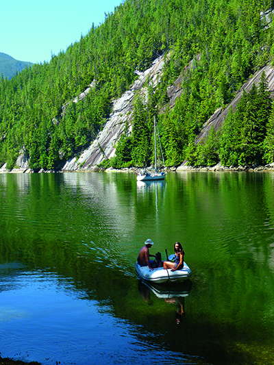
We were in the Broughtons, a relatively new name for an island group that provides captivating Canadian cruising. With its stunning scenery, abundant wildlife, excellent fishing, a 12,000-year-old human history, cultural sites and coastal characters, deserted anchorages and the odd rustic resort, the region is a hidden jewel. It was only in the 1990s, particularly owing to the incorporation of many of the islands into the Broughton Archipelago Park, British Columbia’s largest marine park, that the region gained an identity.
The problem is the time required to sail there. The Broughtons are at 51°00N 126°45W and Vancouver and Seattle, the main Pacific North West population bases, lie 200 and 300 miles to the south respectively.
The first stretch up Georgia Strait to Desolation Sound is easily achieved, but the barrier of the next 60-80 miles of narrow passes, flanked by 1,500m mountains, suffers strong winds, whirlpools and fierce rapids and is a physical and psychological barrier to heading farther north.

Although summer winds can be light we had been lucky on this trip. Leaving Vancouver we enjoyed the last of a 20-knot south-easterly that whisked us north on a favourable current. Our Beneteau, Bagheera, flew along, completing the 76-mile trip to Comox in nine hours. This pretty, well-stocked town on Vancouver Island is one of our favourites. Friends were waving at the Comox Bay Marina and we pulled in. “We are heading to Desolation tomorrow too,” they informed us. “Beat you there.”
We were all former racers and the challenge was on. We consulted the tide charts for slack water at the Comox Bar and found we could leave at a civilised 1000. It was 35 miles to Desolation Sound and the north-westerlies filled in late morning giving a comfortable reach north-east, back to the mainland side, but as we approached the Copeland Islands just short of the Sound the winds failed.
Sundowners in Laura Cove
We both held on, our speed dropping to three knots, then the advantage of their extra 2ft of waterline and a lightly laden boat showed and they pulled ahead, reaching lovely Laura Cove, our chosen anchorage in Prideau Haven, with enough time to have sundowners ready for us all.
We now had to decide whether to take the most direct passage to the Broughtons, the commercially used route up 55-mile Johnstone Strait that follows the Vancouver Island shore, or take the longer, but generally more benign northern passage.
With calm winds and a favourable current Johnstone Strait is ideal, but typically the north-west summer winds gain momentum during the day, reaching over 30 knots and in its lower stretch lies Seymour Narrows where the maximum flood can run to 16 knots. Arriving early at passes and transiting at slack water is a skill that will be put to the test many times and it is essential to have a current copy of The Canadian Tide and Current Tables, Vol 6 or Ports and Passes.
 After listening to the forecast we chose the more northerly route. We were lucky, a light pre-frontal south-easterly gave us a following wind for cruising past Stuart Island, through Yaculta Rapids, Gillard Passage and Dent Rapids at slack water, then gliding north of Sonora, the Thurlows and Harkwicke Island with less than 20 miles required along Johnstone Strait.
This route has several more passes to negotiate and with everyone arriving early our fellow cruisers were becoming familiar. There are some anchorages and a few facilities along this route, with Shoal Bay and Blind Channel being favourite stops.
Many pull into Port Harvey, East Cracroft Island, at the north end of Johnstone Strait, as a welcome break either to anchor or visit the rustic Port Harvey Marine Resort with its small store, and Red Shoe Pub and Restaurant (wear red shoes for a free dessert!). Others may weave north, either to anchor or catch the tide in Chatham Channel then relax at Lagoon Cove Resort, a delightful facility that offers prawns at happy hour, walks, fuel and workshop.
Those needing repairs or provisions will continue to Port McNeill on the Vancouver Island coast, maybe lingering to look for whales and dolphins by Robson Bight Ecological Reserve, and making a stop at picture-postcard Telegraph Cove, the former end of the Telegraph line.
The mall town of Port McNeill has grown in facilities and friendliness, with two supermarkets, a marine store, and repair facilities. There is a good anchorage across the bay and two marinas.

Five miles north-east lies Malcolm Island and the community of Sointula, or ‘Place of Harmony’, in the Finnish language. It is a wonderfully friendly, peaceful place with a unique history. A group of Finnish settlers founded the village in 1901, having become disillusioned by their hard mining life in Nanaimo and established a utopian society thriving on fishing and logging.
A version of utopia
The current community of 500 still operates a relaxed version of utopia, without politics, but with little industry it is challenged to keep its youngsters. On our visit many were visiting for the annual baseball match and there was a lively group in front of the oldest co-operative store in BC, a 20-minute walk from the marina.
A short distance south-east lies Comorant Island and historic Alert Bay. A significant centre for fishing and lumber in the past it now has the region’s largest native community. You can anchor or pull into the public dock. On the south side the colourful village is filled with old buildings dating back to the 1800s.
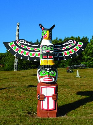
The U’Mista Cultural Centre opened in 1980 and is poignantly placed next to one of the abandoned residential schools where many of the native children were sent. U’mista means ‘return’ and the museum represents ‘the return of treasures from distant museums’. It houses a magnificent display of masks and other regalia of the Kwakwaka’wakw people that were confiscated in 1921. Up the hill the world’s tallest totem pole stands beside a traditional long-house.
To the west and north lie the multitude of islands of the marine park. These provide picturesque gunkholing and excellent kayaking. The abundant sea life and vegetation provided rich resources for the Kwakuitl people who settled the area, before the European pioneers came here in the late 1800s.
To the east lies Village Island where interpretive tours are offered. All fees go towards the continued clean-up and the building of traditional-style long houses.
Close by is ten-year-old New Vancouver. We were welcomed ashore at this original village site, which one extended family, with government support, has rebuilt. After mooring to the sturdy dock, we were shown two totem poles that took the carver a year to complete.
There are a limited number of overnight anchorages within these outer island groups. These are affected by the winds in Queen Charlotte Strait, which is open to the Pacific Ocean. After a daytime stop many cruisers will head to large Gilford Island, most calling in at Pierre’s Echo Bay Lodge and Marina to stock up with stores, fuel and water, to enjoy happy hour and indulge in one of the regular summer feasts.