
World and European Championship-winning professional navigator Tom Cheney talks through the challenges of the RORC Caribbean 600 course
Inaugurated in 2009, the RORC Caribbean 600 is a relatively recent addition to the calendar of 600-mile offshore yacht races, adding to the list of established bluewater classics like the Rolex Fastnet and Sydney Hobart races. Its route, around 11 of the Leeward Islands in the Caribbean, is one of the most navigationally challenging of the 600-milers.
Starting and finishing in Antigua, the race’s 12-leg, figure-eight type route stretches from St Martin in the north to Guadeloupe in the south, weaving a Caribbean course that is as stunning as it is demanding.
The consistent north-easterly tradewinds and the looping nature of the course will exercise every sail in the wardrobe, and rewards boats set up for performance on all points of sail. There is far more fetching and reaching in this race than in a typical Fastnet or Sydney Hobart, for example. The sheer number of legs and sail changes are also a great challenge for crews and navigators alike.

The Caribbean 600 Route
Caribbean 600 start
The starting line is off Fort Charlotte on the rugged coast of Antigua at the eastern entrance to English Harbour, above the Pillars of Hercules and below Shirley Heights. The first part of the race is an eight-mile beat to Green Island, the easternmost point of Antigua. While the Caribbean 600 doesn’t usually attract as many entries as a race like the Rolex Fastnet, this first leg can still be very hectic, as boats battle for the convergence on the left under cliffs and headlands. There are a couple of rocks to look out for here, a particularly noteworthy one at Standfast Point, although this is well charted.

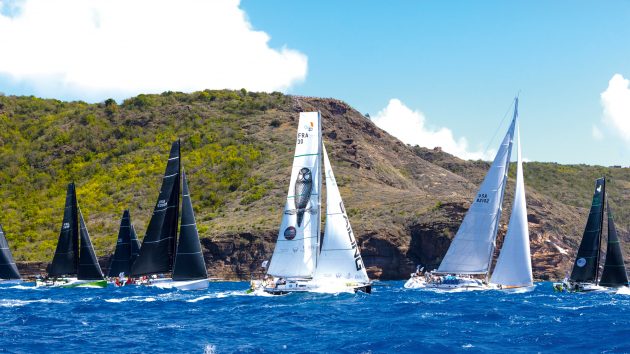
Comanche at the start of the RORC Caribbean 600 in 2022 – the race often attracts a mix of local, charter and visiting yachts. Photo: Arthur Daniel/RORC
From Green Island you can sail the rhumbline to the inflatable rounding mark off Barbuda while paying attention to the Antiguan reefs. In big seas this might not be the case, and you may want to give the lee shore some more room. Usually this leg is around 090° TWA, but it’s risky to try to set reaching sails too early on this leg as there is very little runway to leeward for the first seven miles.
Anticipate the wind dropping and lifting you as you approach Barbuda. You will likely be VMG running by the time you reach the mark and may even have to gybe.
Barbuda to Nevis
This is usually a long (50-mile) downwind VMG leg. There is a wind shadow in the lee of Antigua, which is often indicated by a long cloud street. Once through the wind shadow, the wind will likely be 10° to the right of the gradient as the breeze wraps around the island, this is a nice header on port if you time the gybe well. It will likely be the evening of day one by the time most of the 40-footers are at Nevis.
Nevis to Saba
This leg is another 50-mile leg, broad reaching behind Nevis and St Kitts. Nevis is particularly tall and there are lots of land effects as you sail in the lee of the islands and the funnelling channels between them. Once again the wind bends as you approach the shadow of Nevis and St Kitts – you will likely hang onto a spinnaker for longer than you initially expect.
Saba is also tall and there is a two-mile leg to sail up very close to its western shore. Watch out for dive buoys and be ready to be in wind-seeking mode when in the worst of the wind shadow. Getting too far from the island will be punishing as the next leg will be proper upwind VMG.

There are rocks and outlying islands to avoid when rounding
St Barths
Saba to St Barths
Rounding the north of Saba, the wind first bends right around the island – so there is a small gain by taking a hitch in to get the lift – then it becomes a header as you sail back into the gradient breeze.
Often this leg is one of the lumpier upwinds, if this is the case then a good strategy is to get to the left into more sheltered waters on the shelf in the lee of St Barths.
St Barths to St Martin
The smaller boats should benefit from doing this next leg in daylight – useful as there are plenty of rocks and outlying islands to avoid. Slower boats also need to keep a lookout for the faster boats on a reciprocal course, having already rounded the top mark.

Tom Cheney and the Sunrise team competing in the 2022 RORC Caribbean 600
The first rocks, Les Grenadiers, are steep sided, so you can get close to them. A header around Les Grenadiers often makes you feel like you won’t be able to lay Ile Toc Vers, but as you get offshore, the wind will likely lift, so don’t worry if you are initially low of the layline.
Don’t rely on the charted positioning of Roche Table (Roche Plate). It is steep sided though, and visible, so you can get very close to it once you’re confident of its position. Pay attention to Les Roches Rouges: there’s an uncharted shallow spot at 17°50’.6N, 062°50’.6W.
St Martin to Tintamarre
From the westernmost corner of St Martin you are back to upwind VMG towards Tintamarre. There is significant foul wind-driven current offshore. Before you get lifted, get back inshore, otherwise it’ll be hard to get back. There are some good gains to be had short tacking inshore, making the most of wind bends on the headlands, although there’s a risk it could be light and flukey in places.
Be aware of Spaniard Rock between Eastern Point and Tintamarre. It is possible to get inside Spaniard Rock for some sea state relief and possibly a tiny lift around Tintamarre.

A long wind shadow is found in the lee of Guadaloupe
Tintamarre to Guadeloupe
This is the longest leg of the course, 150 miles, from Tintamarre and St Barths down to Guadeloupe avoiding Montserrat.
The initial part of the leg from Ile Tintamarre to St Barths is always tighter than you think and is almost hard on the wind. The current does seem to change direction here, so keep an eye on course to steer and keep COG-ing at the mark. Try not to get low of rhumbline, sail the shortest distance and anticipate being headed around St Barths.
St Barths to Guadeloupe also ends up tighter than everyone expects, often 60°-70° TWA. There is a decision as to which side to pass of Montserrat. The shortest course is to stay to the east of it. Don’t get too close to the windward side of Montserrat, as there can be a bit of a windward bubble.
The wind shadow of Guadeloupe is often the most challenging part of this race. Time of day has a big effect on how soft the conditions are, but many boats arriving during the night get becalmed for hours. There is a high resolution WRF GRIB forecast available that models the size of the shadow well, although it can sometimes be optimistic about wind strength.

The 70ft trimaran Maserati flying into the finish – the final stage is usually upwind from Redonda to Antigua. Photo: Arthur Daniel/RORC
Pick a point as a target and aim for it, eg Pointe Des Peres. Getting half to one mile off the beach has been the winning option for most races. There’s no point getting a long way offshore, because all this distance will be ground to sail upwind again later. It’s also unwise to end up in a no man’s land around two miles offshore. Stay pretty close and there’s a good chance of drainage breeze through the night. If you do get stuck in no wind, just push south, as that’s the quickest route back to the breeze and to the next mark.
After the long reach to Guadeloupe you’ll head up and beat to Les Désirade, leaving Iles de Saintes to port. There are some tricky bits to this leg including a rock off Grand Ilet and an exclusion zone around Terre de Bas. There is often a large wind speed increase at the bottom of Guadeloupe.
People are normally tired by this point and it’s a hard beat. There are also lots of lobster pots. Désirade is a bit hairy and has lots of rocks, so give it a good safety margin.
Les Désirade to Barbuda
After Les Désirade there is another long reach at approx 100° TWA. It will help that you’ve already found the inflatable at Barbuda once before, particularly as it may be getting dark when you get to it the second time. This is usually a fast leg but a good one for a navigator to get some rest. It can be a little demoralising sailing past Antigua, finish in sight, but with 115 miles of race left to go.

The leg to Redonda is often a broad reach but can be downwind – if so make the final 10 miles on port layline for cleaner air. Photo: RORC/Tim Wright
Barbuda to Redonda
Likely a gybe set at the mark, the leg to Redonda should be a fairly simple broad reach. Be a little wary of getting into the wind shadow of Antigua. As before, this should be signposted by a long cloud street. If this leg is more of a downwind than a reach, it’s best to do the final 10 miles on the port layline.
Redonda to Antigua
The final 34 miles upwind to the finish should be a fairly square beat. Once again the wind shadow of Antigua comes into play and this could be a final opportunity to get some leverage by picking the correct side of the beat.
If the wind is left, then stay further offshore and sail up the south side of the clouds. If the TWD is right, then a rule of thumb is to get left to benefit from the starboard lift on the edge of the Antigua wind shadow and flatter sea state.
At the very end there are gains to be had inshore, but stay outside the reefs. There are nice lifts coming out of Curtain Bluff and another out of Rendezvous Bay, but you need to get right onto the beach to get the left-handers.
 If you enjoyed this….

Yachting World is the world’s leading magazine for bluewater cruisers and offshore sailors. Every month we have inspirational adventures and practical features to help you realise your sailing dreams.Build your knowledge with a subscription delivered to your door. See our latest offers and save at least 30% off the cover price.