
Meteorologist Chris Tibbs explains how to navigating using Google Earth and shares his experience of using this software

We have got used to chartplotters and GPS being very accurate; sometimes (I think) too accurate as we pass ever closer to obstructions, confident we’ll be safe because it shows them on a computer screen.
But when cruising further afield we need to understand that the charts may not be as accurate as we’d like them to be, and we need to sail more conservatively than we might, for example, in north-west Europe.
When sailing among coral the first tactic is to use eyeball navigation: with clear water and the sun behind it is quite clear where shallows are and what needs to be avoided. Hoisting someone aloft to look down from the spreaders can aid navigation.
Polarising sunglasses are useful, but the sun must be behind you otherwise glinting from the sun makes the depth unfathomable. On a cloudy day it is most difficult to determine depths. It takes a lot of practice to estimate actual depth but it is relatively easy to separate shallow from deep water.
Google Earth and Open Source
Using satellite imagery takes the concept of eyeball navigation a stage further. With Google Earth, zooming in on an area where there is coral we can quite clearly see just where there are shallows and deeper areas. We can add a GPS so that our position is seen on the image.
However, some Google Earth images are affected by cloud cover, or the sun was at the wrong angle when the image was taken. Fortunately a history slide bar allows you to go back through previous pictures of the area to find the clearest view. That’s great when using broadband, but on a poor connection can be slow and time-consuming. There’s also a 2GB restriction in the cache memory for use offline.
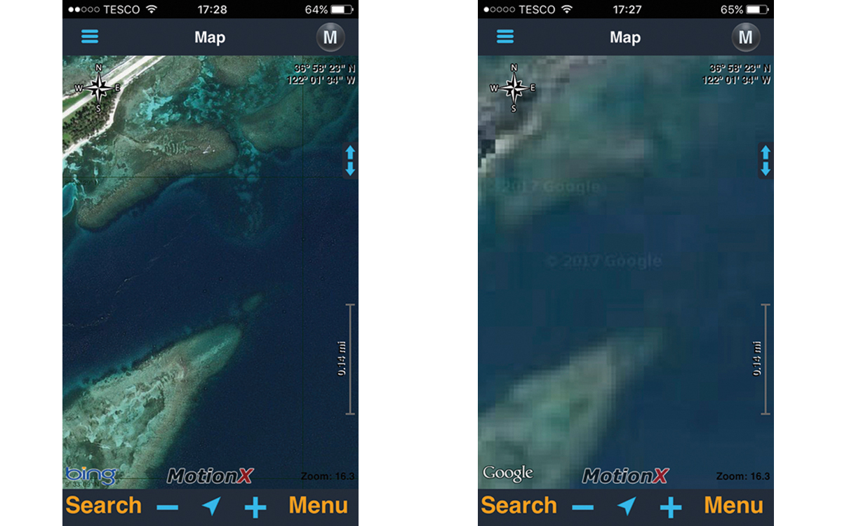
With the MotionX app you can switch between satellite images to find the clearest
Many cruisers use Open Source CPN, which is chartplotting software on a laptop. There are many free charts you can download onto this software, as well as ones to purchase. One great use of the software is that you can overlay satellite pictures onto the plotter on your laptop by using GE2KAP software (what I used), which has in turn been superseded by Sat2Chart.
This software takes a satellite picture of your choosing and converts it into a KAP file that’s readable on the chartplotter. This removes any problems of the 2GB cache memory for offline work and cruisers will quite often share images that they have converted. The Sat2Chart software will also convert from SASPlanet, another program for downloading high-resolution imagery and maps that can stay on your computer.
All this can be quite fiddly and time-consuming for those limited in IT skills, although if I can manage it so can anyone!
App images
One lovely thing about bluewater cruising is the friendliness and generosity of fellow cruisers. In Fiji we were introduced to a simpler way of using satellite imagery for navigation through an app. If you use an iPhone or iPad, GPS MotionX is an app that takes out a lot of the hard work.
Using the app, you can download, at your leisure, high-resolution satellite pictures. There is a choice of satellite images (Google, Apple and Bing) and by switching between them you can get the best image, or even find road maps for when ashore.
The Android alternative we tried was GPS Essentials. Although that’s good we preferred the GPS MotionX and if sailing the Pacific again would buy the biggest iPad available just for that function.
When using the app and satellite pictures, or with open source CPN on a laptop, it’s critical that we use them as an aid to navigation and not as a complete tool. There have been a number of groundings by crew using tablets, and even with all modern navigational aids yachts still come to grief around reefs and atolls.
Article continues below…
Forward-facing sonar: Everything you need to know
Yachting is usually pretty fast to embrace useful new technology, particularly if it helps win a race or if it…

Can augmented reality really give us a vision of the future of sailing?
Google’s mission statement is ‘to organise the world’s information.’ This almost impossibly ambitious declaration of intent underpins the technology giant’s…
Our experience
In harbour we’ve downloaded open-source CPN and charting, and been kindly given some satellite images. The open CPN charting was rather out of date and not as accurate as the Navionics on our chartplotter.
Before each day’s passage we compared the Navionics on the chartplotter and satellite imagery. We used Google Earth on the open CPN and the GPS MotionX, which we relied on more heavily the more we got used to it.
Rather than plot a route of waypoints I’d mark the position of reefs and coral outcrops on the app and add these on the chartplotter. Where these tied in with the charts we had a great deal of confidence but where they didn’t we proceeded with caution. Entering bays and through passages we’d still rely on eyeball navigation, timing our arrival so the sun was behind us.
Satellite imagery is not perfect, there will always by patches that are difficult to determine if there is a shadow from cloud or a shallow patch and sometimes the higher resolution satellite pictures do not give total coverage.
Although we found a good degree of accuracy with the satellite pictures we tried to verify the position of features by using a hand bearing compass and radar. This would help to confirm GPS position and the datum used on the chart.
 About the author
Chris Tibbs is a meteorologist and weather router, as well as a professional sailor and navigator, forecasting for Olympic teams and the ARC rally.
First published in the November 2019 edition of Yachting World.