
Exploring the South Atlantic using celestial navigation turns into a three-year quest for a little-visited archipelago, by Kate Schnippering
One foot east, one foot west. I stand on a line inscribed in stone: the Prime Meridian, longitude of zero. This threshold marks a rite of passage for becoming a celestial navigator. It’s April 2023 and I’ve journeyed a long way to the UK for my RYA Yachtmaster Ocean exam, where I’ll be extensively questioned on the South Atlantic passage I sailed the previous year with Vinson of Antarctica, and on the ins and outs of my navigational records.
I’d spent six weeks aboard the expedition vessel, first learning the basics of wayfinding by sextant from shore, and then putting it into practice on a 4,000-mile downwind delivery strewn with storms and turbulent seas. I didn’t realise then, but I was embarking on an even bigger journey that would take three years to complete.
One year in, I’m warming up by visiting Greenwich Observatory to see first-hand the chronometers of John Harrison, who solved the challenge of determining longitude at sea in the 1700s. As I admire the exquisite pocket watch, I imagine H4 ticking away on a creaking old ship, faithfully telling Greenwich time and keeping the rocks at bay.
Crew mate Carlos taking sun sights in the South Atlantic. Photo: Kate Schnippering
Nonetheless, the Royal Society was unimpressed by this mechanical solution, and they withheld Harrison’s prize for more than 20 years, believing a more elegant answer lay in calculating the moon’s paths. Today, we navigators consider the moon the least reliable object to take sights of!
Beyond the allure of duelling mathematical proofs, I’m fascinated by the earlier timepieces built to time’s variable rhythms. Sundial rings. Tide-watches. A Nocturnal star-clock with an extended pointer to touch time on your skin at night. I want to feel a connection with Greenwich in my bones, so perhaps someday I won’t need a timekeeper to know my longitude.
Celestial navigation beckons modern sailors back to a lost romance with ocean voyaging that’s been stifled by a proliferation of technology. We slow down to take in more of our surroundings, and exchange full control for an unfamiliar form of guidance.
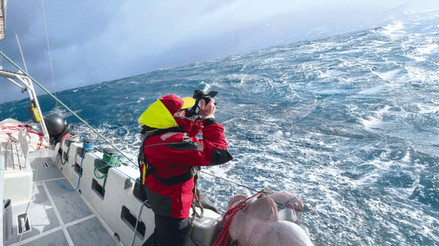
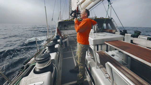
‘Drop shades. Scan the sky to catch the sun in the eyepiece’. Photo: Kate Schnippering
We form personal relationships with the sun, moon, planets, stars, islands, birds, and winds, who become the protagonists and antagonists of our stories. The art of navigation has the power to change why we voyage in the first place.
I reflected back on the past year. How had I arrived at this threshold? I joined the passage on Vinson not because I needed to navigate if the GPS on my Catalina 36 Petrichor failed, but because I felt lost in a larger way.
I was experiencing stagnation in my decade-long dream career at a prestigious design firm. In pursuit of impact, I found myself growing out of touch with my own creativity. I sought renewal, and turned to the unruly Southern Ocean to chase mystery, without an end destination in mind.
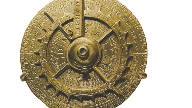
The Nocturnal was an early navigation tool to determine time from the position of stars
Longitude, Meet Latitude
April 2022. The last piece of land receding in the distance is Isla Hornos, marking a notorious Cape where Pacific clasps Atlantic. While there is no line drawn here, I feel the two oceans clashing with omnidirectional waves of all character. They tango, tussle and trebuchet into each other. The autopilot surrenders and our skipper, Kenneth Perdigón, takes the helm.
We have too much sail up for 35 knots of wind, rushing to our five-minute appointment with a daring helicopter documenting Vinson’s first pass of the Horn. Finally we reef – and tape over the GPS display of our position. From here on, we’ll navigate without it. As night falls, a formidable ocean reaches before us. Our destination Cape Town lies a quarter-turn around the planet.
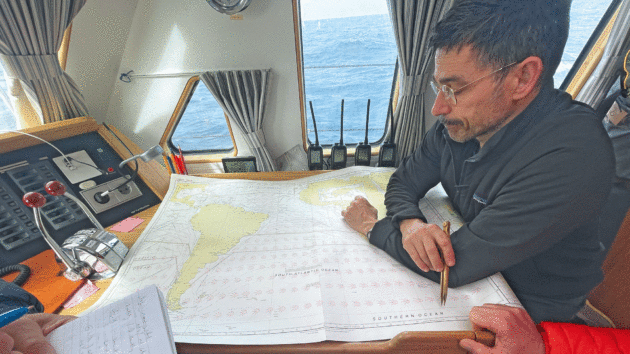
Skipper Kenneth Perdigón studies the chart. Photo: Kenneth Perdigón
I’m one of six apprentice celestial navigators, who’ve just learned in theory how to get from here to there via pencil, paper charts, almanac, tables, sextant, wristwatch, and compass. We’re daunted at the task, and begin to plot our dead reckoning course hourly, estimating our compass heading and distance logged.
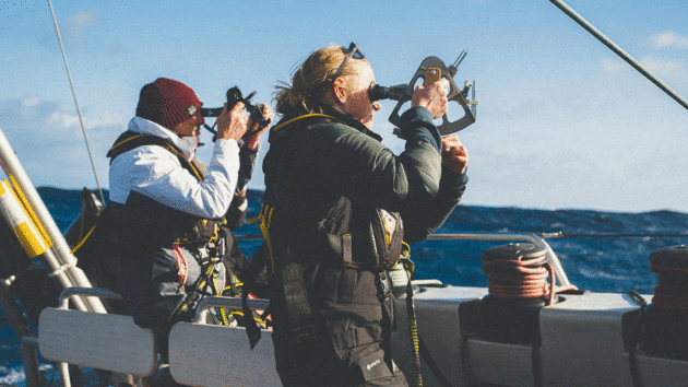
Leaping on deck to meet the sun with sextant in hand is Carlos, exclaiming his boundless enthusiasm for planetary physics. My cabinmate, Tim, and I follow more timidly, working together to take sights and record data. Clip on to a strong-point, it’s time to arm-wrestle infinity with a small metal instrument. Align mirrors with a wobbly horizon. Drop shades. Scan the sky to catch the sun in the eyepiece.
Where is it? Shades are too dark… too bright!… just right. Copy the sun, drop the green orb to graze the edge of the sea-sky ruler. Mark! Record time, altitude.
Christian working on navigation on Vinson of Antarctica. Photo: Kate Schnippering
After a math marathon through a labyrinth, Tim and I yield our first fix of latitude and longitude – correcting our course by 30 nautical miles. As the days go by, it gets easier. We face every trapdoor error in turn, slowly building trust in the process, and attuning to the experience of living on a sphere.
The method we’re using evolved in the 1800s – decades after Harrison’s chronometers – and has a simple concept behind it: each celestial object projects a circle onto the earth, and when we intersect two circle-projections (usually morning and afternoon sun), we know we must be at one of the two points where they overlap.
We can pinpoint our position anywhere on earth by comparing the expected measurements from where we think we are, to the ones we’re actually recording.
On a Great Circle route, the curvature of the earth matters, and our heading gradually bends. The sun takes centre-stage. Port side, declination north, marching into austral autumn. Sunrises arrive earlier as we cross timezones.
Miquel admires the moon after taking a sight at dusk. Photo: Kate Schnippering
We attend each day’s local noon, where a sight produces our exact latitude. What keeps us racing to plot the next position is our aim to locate a petite 14-mile-wide island in the middle of the Atlantic: Tristan da Cunha. The most remote inhabited place on earth, a settlement situated on the edge of a volcano.
Two low pressure systems pass, bringing 50-knot winds and 7m swells. Closely monitoring the radar for approaching squalls, on the ‘Betelgeuse’ watch we dress in full foulies and stand by on deck. Here at 0200, perched by the aft mast above the pilothouse in horizontal rain, is a perfect moment to slow down and think through a coordinated manoeuvre together with first mate Justino, fellow navigator Chris, and 15-year-old trainee Antón.
Celestial Navigation: Invisible Forces
While navigation can show us where we are, it cannot take us everywhere we want to go. We are at the whims of the sea’s invisible forces. A third low pressure system brings tremendous head seas. Tack as we might, no amount of patience will open up a path to Tristan da Cunha. Our skipper makes the call that we must re-route, and we are crestfallen. What are we navigating for, then?
New calculations show a reasonable course via Gough Island – is it worth the effort? Over the ship’s satellite email, Vinson’s managers Skip Novak and Jordi Griso send us the latest edition of Gough’s newsletter, The Bunting – highlighting fur seal pup weighing and the small crew stationed there for the winter. Spirits pick up briefly, until the fog sets in.
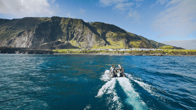
Heading ashore by dinghy at Tristan da Cunha. Photo: Kate Schnippering
Accompanying the fog are perfect sailing conditions, and we’re sailing so fast we’ll likely pass Gough in the cover of night. We depower sails to slow Vinson down. Kenneth informs us that if we miss our 8-mile island on a 20-mile radar range, we’ll not be turning back. We plot our course every 15 meticulous minutes, aiming for Gough’s centre.
Instead of clear-cut sun-sights, we’re plodding our way forward by dead reckoning alone. The more we can account for the invisible actors influencing our course, the higher the hopes for our needle-in-haystack island search.
Rotating between sleep-deprived navigators we must collectively agree upon magnetic variation, compass deviation, leeway, and ocean currents. I roll off my night watch to cocoon into sleep, mired in doubts that our efforts will amount to anything. Good luck Rob, Tim and Maurice.
Tristan da Cunha is long way from almost everyone else. Photo: Kate Schnippering
When I return to the pilothouse the next morning, Gough Island has just appeared on radar. We are off-course by a mere 12 miles, almost three days since our last sun sight and 17 days since we switched off the GPS. High-fives all around!
A grey silhouette is visible off starboard bow. As we draw nearer, we revel in the magic of islands forming their own microclimates. All gather awestruck on deck to watch the cloud curtain lift to reveal verdant waterfalls pouring over cliffs, scores of seabirds of flocking together – spectacled petrels, prions, sooty albatross, wanderers, and great shearwaters galore.
Kenneth radios the research station, and the winter crew invite us to imaginary coffee – we all know we can’t land on Gough. They line up outside, waving, as we sail by.
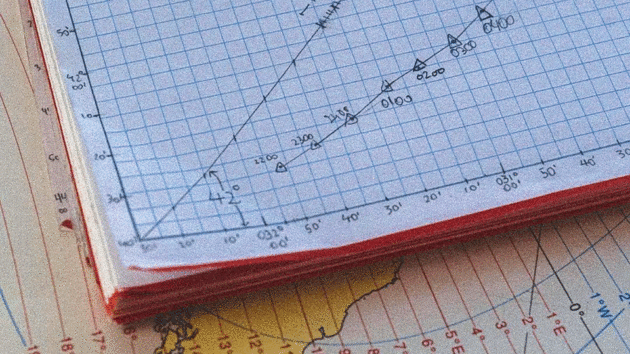
Recorded data for the sextant sights. Photo: Kate Schnippering
For whatever reason, those benthic guardians who protect Tristan da Cunha had called up the sea to bar sailors who were not yet ready, and sent us to Gough instead, a place more dazzling than I dared imagine.
I’m ready to embrace wandering as a form of navigation.
Article continues below…
Saint Lucia: not just a transatlantic stopover
At the end of a long transatlantic crossing, the island of Saint Lucia is a dreamlike landfall. Its hills and…
Sailing the Transatlantic Race on Hound: ‘Hound is a poster child for a bygone era of yacht design’
It’s early morning on 25 June, and last night was tough. The wind peaked at 32 knots and up on…
Slippery Subjects
April 2025. Three years later, and I’m back in the South Atlantic, sailing from the Falklands to Cape Town, with a second chance to reach Tristan da Cunha.
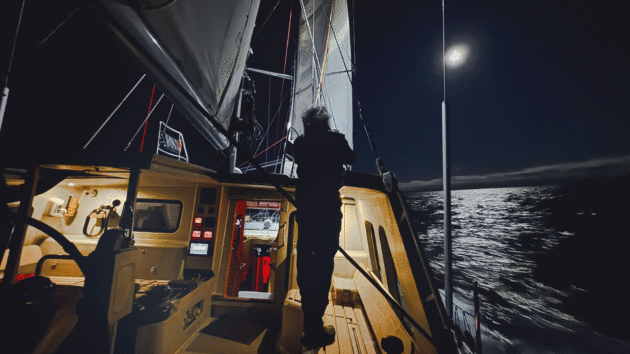
Now, I’m a crewmember of Vinson’s twin sistership Amundsen, and a mentor to four apprentice navigators. I’ve committed to the 0300-0700 and 1500-1900 watches for the whole passage – every chance to shoot stars during the brief windows when the horizon is crisp. The beauty of the stars is being able to take three or more lines of position, quickly working out our position in the moment. They are slippery subjects, visible one instant, gone the next.
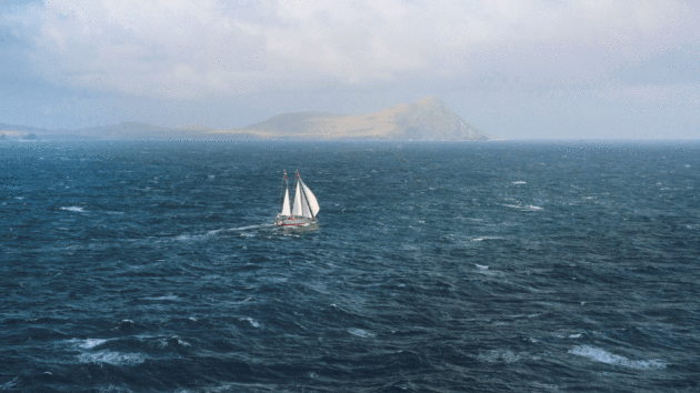
Photo: Scott Gallyon
To keep awake in the long-haul nights, Ian calculates the Selected Stars and their expected bearings: bright Sirius, Alpha Centauri, Canopus, and Rigel, Red Antares and Betelgeuse, elusive Fomalhaut, Achernar, Altair, and Enif.
With 21 days to know twilight I observe skies that are often clear in the early hours. Clouds rush in as we optimistically open a sextant case. Other dawns offer thick mist with no daybreak, the yellow dwarf star sleeping fast under a grey blanket.
With the sun becoming unreliable for such long stretches, our apprentice navigators must go even deeper into creative calculations using all observations and data sources, to cobble together any act of navigation. What heading clears the latest ice limits? They monitor the seawater temperature while skirting the Antarctic Convergence.
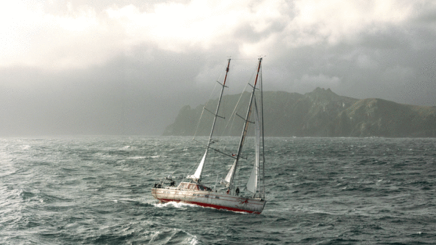
Pelagic 77 Vinson of Antarctica rounds the fearsome Cape Horn at the very bottom of South America. Photo: Kate Schnippering
The lack of wind is so uncharacteristic, the routing charts inform us we can’t possibly be where we are. There are many clues we can’t decipher, each a trace
of a greater pattern. The wind-sculpted swells carry news illegible to us.
After five days of fog, evening clouds finally free the moon, and in the sparse minutes before the horizon disappears, Miquel snags a sight of the lower lunar limb, which produces a single line of position. Half the information needed to confirm a fix. The following morning, Claire tags Venus. The puzzle starts to fit.
Imaginary Islands
For three years now, I’ve been imagining Tristan da Cunha. I close my eyes and see the island forming. Magma stirs with ash. A seawater pressure cooker of 200 atmospheres pressing down like a hot iron. Boiling, steaming, whistle shrieking. One Pleistocene morning, a raw new rock rises up from soupy slumber.
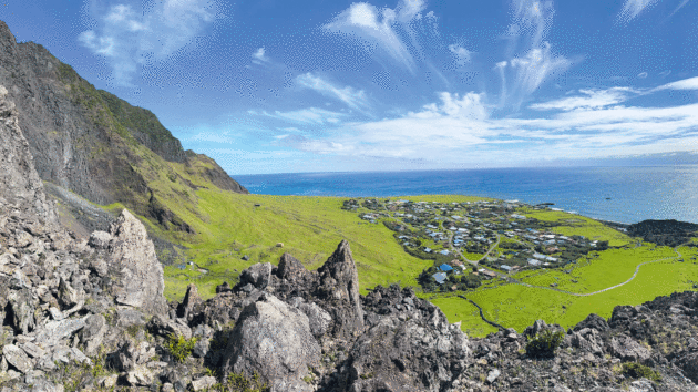
A steep climb up a basalt hill rewards the author with a panoramic view of the Tristan da Cunha settlement Edinburgh of the Seven Seas. Photo: Kate Schnippering
Although it housed no human inhabitants for most of history, the subtle presence of the landmass must have affected all that unfolded since. Casting eddies as dice across the vast Atlantic, remaking each wave that lapped the shores of Africa, Europe, and the Americas. Perhaps a skilled early navigator suspected the archipelago from a long way off, before Admiral da Cunha first sighted the island of his namesake in the 1500s.
The British established a foothold on the island to thwart Napoleon, and went on to establish a World War II naval outpost, and ultimately a permanent community.
Tristan da Cunha is not on the sailing route. For us to reach it takes an incredible confluence of conditions.
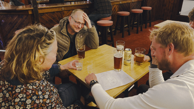
Puzzling over astro in a pub. Photo: Kate Schnippering
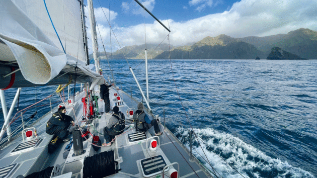
The variables of weather, wind, sea state, and timeline all harmonise for us. After two weeks of drawing tiny lines and measuring sun angles, our apprentice celestial navigators locate Inaccessible and Nightingale Islands by radar, and chart a course between.
In the earliest hours of the morning, Venus, Saturn and Mercury crest together above the silhouette of Queen Mary’s Peak, the lights of Edinburgh of the Seven Seas twinkling. Terns fly near to inspect us. Kelp clings to our rudder. Plant and earth scents lure us in, sweet notes over the salt spray.
We anchor on the volcano’s edge, in open ocean swell. A large group of Tristanians assembles at the harbour, waving. Indeed, they have been standing watch for us. Skipper Paul Guthrie, and the four apprentice navigators dinghy ashore to greet them. I wait on Amundsen with fellow crewmember Yannick serenading Catalan guitar to the galleyware percussion as the pots and pans slide port, starboard, port with the swell.
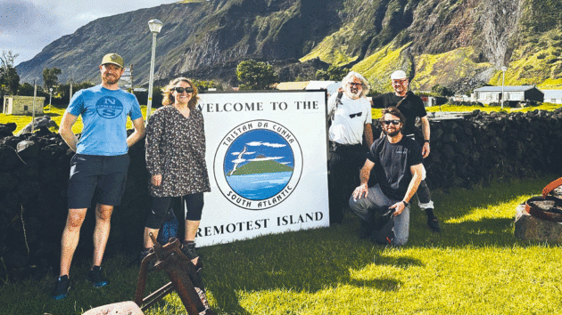
Apprentice navigators in Tristan. Photo: Kate Schnippering
At my turn ashore, I scramble off-trail up a basalt hill. Sweaty from the demands of wobbly legs, I pause and breathe in this scene that is no longer a dream, but just as precious and precarious. Careening cliffs. Cumulus clouds for a cap. Surf battering beach. Lawn chairs posing with lava rocks. Multi-coloured rooftops reverberating with church bells, barking dogs and motorcycles.
Later, we sail into the night. This island that for years approached slowly on my horizon, now begins to recede over our stern. Although for a few enchanting hours it proves to be real, it quickly returns to my imagination – in memories, textures, smells and photos.
On the final leg of the passage, I read Sea People: The Puzzle of Polynesia by Christina Thompson. The Polynesian navigators have incredible knowledge of the stars, and can effectively navigate by the stars’ paths of rising and setting, with neither sextant nor compass.
I now realise the Polynesian navigators have no need to feel Greenwich in their bones. They have something else. I’m particularly captivated to read about the navigation technique involving an imaginary island, called an etak. One familiar coastal navigation technique is to take bearings off charted objects.
Picture a perfect chain and islands, each coming and going over the horizon in turn, segmenting the journey’s progress from start to destination. Now, take away the actual islands.
The Polynesian navigation technique involves mentally visualising and tracking bearings to these imaginary islands, allowing seafarers to locate themselves without the use of observational clues. So our stories and dreams can be guideposts – tools for navigation as powerful as our technology.
Wing-on-wing I run onwards, taking bearings on those stars and islands that appear through the clouds – reference points that compel my journey into the uncharted unknown.
 If you enjoyed this….
Yachting World is the world’s leading magazine for bluewater cruisers and offshore sailors. Every month we have inspirational adventures and practical features to help you realise your sailing dreams.Build your knowledge with a subscription delivered to your door. See our latest offers and save at least 30% off the cover price.
Note: We may earn a commission when you buy through links on our site, at no extra cost to you. This doesn’t affect our editorial independence.