
A year cruising Indonesia is a chance to explore deserted islands and unforgettable underwater life for Catherine Lawson
The night is almost over when we motor our dinghy across Namatote Strait, drawn by the glinting fluorescent bulbs of a dozen fishing trimarans. The lights that attract the nightly catch lure us in too, and we call to fishermen as we draw alongside for ‘ikan besar?’, or big fish – and by that we mean whale sharks.
Moving from boat to boat, we race against the rising sun that heralds the moment when nets are hauled up and the whale sharks return to the depths. A fisherman waves frantically to us and we zip across to tie up alongside, donning fins and masks and slipping silently over the side. Through the clearest of waters, warm and calm, a whale shark circles languidly up from the seabed, its enormous mouth agape to scoop up the sea.
A second whale shark appears and we glide together, diving deeply and pushing every breath hold to linger in this mesmerising, fleeting dance.
Sizing yourself up against the planet’s largest fish is as memorable as it gets, and it’s experiences like this that bring sailors to Indonesia’s wild, West Papuan coast. From November through to April, whale sharks follow the plankton-rich currents funnelled into Triton Bay, where local fishermen broker incredible encounters for as little as £15.

Calm conditions dominate during the north-west monsoon. Photo: David Bristow
Triton Bay is about as far east as you can go in Indonesia and still be on the sea. There’s one friendly resupply town (Kaimana) and a solitary dive resort (Triton Bay Divers), while a maze of towering karst outcrops hide the most breathtaking of anchorages. Hornbills turn heads as they launch themselves from lofty limestone pinnacles, and when you’re done with the day’s diving, you can dinghy tour along a seawall etched with ancient rock art.
But Triton Bay is only the beginning.
Tropical conditions
The Indonesian Archipelago is huge and the 17,508 islands that cradle Asia’s south-eastern fringe stretch for more than 2,700 miles. It’s a lot of ground to cover, and we’ve spent almost a year cruising from east to west – though it may come as a surprise to learn just how infrequent good sailing days can be.
Equatorial winds are flippant beasts, coming in stops and starts, and usually much lighter or stronger than is ideal. The best time to explore far eastern Indonesia, and Raja Ampat in particular, is during the November-to-April north-west monsoon when skies are clear and whale sharks and manta rays gather in great numbers.

Occupying a corner of the world-famous Coral Triangle, Raja Ampat dazzles ocean lovers. Photo: David Bristow
This is a time of relative calm around the equator however, and if the wind blows at all, it comes from the northern quadrant. The wind occasionally arrives in unexpected blasts of 25-45 knots – equatorial squalls, known locally as ‘badais’ – that interrupt the windless tranquillity with little warning.
If your plan is to move slowly south and westward, April to May in eastern and central Indonesia is a moody time of transitional weather with brief, but regular, rain squalls and breaks in the prevailing westerly winds that patient sailors use to make their leaps. By June, the south-east tradewinds have begun roaring across the top of Australia, allowing you to shake out sails and shut down engines for swift rides across the top of Flores, Bali, Java and Sumatra, onto Malaysia and Thailand.

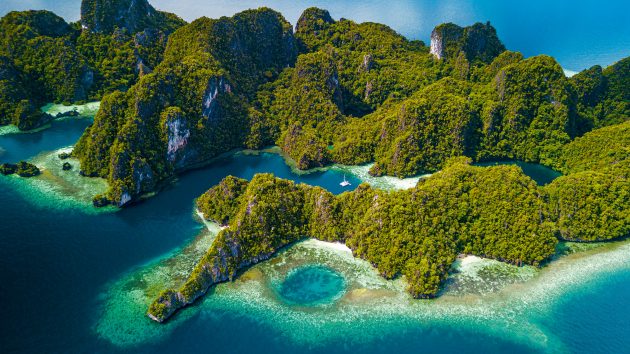
Raja Ampat’s Four Kings
Few destinations fuel tropical dreams quite like Raja Ampat, located about 20 day sails north of Triton Bay along the West Papuan coastline. In this majestic corner of the world-famous Coral Triangle, deep, powerful currents carry with them the kinds of large marine mammals that make divers’ hearts sing, and the biodiversity is simply insane. Think manta rays, dugongs and sea turtles, along with the highest density of reef fish ever recorded, and a whopping 75% of the world’s coral species.
Daylight sailing is the preferred way to journey the West Papuan coast to Raja Ampat. En route, you’ll encounter a motley fleet of local fishing vessels, FADs (anchored fish attracting devices) and Sulawesi flying fish boats whose long nets encourage flying fish to lay their eggs on palm frond platforms at sea. Tangling with any of this at night is best avoided, not least because you’ll likely end up overboard with a knife and a dive torch, and negotiating compensation with angry fishermen for the cost of their damaged nets.

Anchorages aplenty mean you can explore the area with short day sails. Photo: David Bristow
Once you reach Raja Ampat, you can nestle into island anchorages beneath towering limestone walls, and explore forests that are home to flightless southern cassowaries, cuscus (a type of possum) and Raja Ampat’s own red bird of paradise. Known to Papuans as Cendrawasih and thought to be the reincarnation of fairies, red birds of paradise put on splendiferous sunrise shows, and expert trackers around Friwen Island collect cruisers at first light for early morning forest wanders.
Saved by its sheer isolation, Raja Ampat might be overrun were it not so far from Bali, and sailors who arrive via Darwin, Davao or Malaysia’s Kota Kinabalu have these cruising grounds largely to themselves. The Raja Ampat region is divided into the Four Kings: a quartet of pristine marine island sanctuaries that surround the mainland port of Sorong.
Raja Ampat’s remaining three ‘Kings’ lie a few sailing days to the north, separated by the Dampier Strait that memorialises English explorer, privateer and pirate, William Dampier. A three-time circumnavigator, Dampier finally gained esteem with the 1697 publication of his book A New Voyage Round the World, and was later given command of the warship HMS Roebuck. In 1699, after sailing the Roebuck up the West Australian coast, Dampier reached Timor and pushed north through Raja Ampat’s Dampier Strait.

Manta alley in Komodo National Park. Photo: David Bristow
Diving in Dampier
Today, the Dampier Strait is renowned for its swift, plankton-rich currents and the marine life that feeds on them. When it’s time to change anchorages, be sure to set out when the currents are moving in your favour. Making overnight passages poses no out-of-the-ordinary challenges, but with so much to explore, the vast majority of sailors restrict themselves to day sails of between 10-40 miles so that they don’t miss a thing.
Manta rays are common in the Strait from October to April, and there is the best chance to encounter whales in Indonesian waters while sailing through here. The channel has its own MPA (marine protected area) and islands here – Arborek, Kri and Mansuar – provide some truly memorable dives. The downside is that anchorages and moorings within the strait are limited, and the fast flow doesn’t foster sound sleep.

A simple life for local fishermen. Photo: David Bristow
In the middle of the strait, off Pulau Airborek, we plunged into the current at Manta Sandy into an underwater world just exploding with life. After freediving with great mantas, we took refuge by tucking behind Bunibah Island in nearby Gam Bay. This anchorage has a habit of waylaying unhurried cruisers with its off-the-boat snorkelling and chance to spear coral trout along the drop-off. We drifted with turtles and small mantas along the strait’s northern edge, and dinghied through a myriad of blue-green lagoons and jagged sea pinnacles, riding out the northwest monsoon’s blustery squalls with ease.
It was on Gam Island that naturalist Alfred Russell Wallace synthesised his theory of evolution, crediting his clarity of thought to a bout of malaria. In his book The Malay Archipelago Wallace called Raja Ampat ‘the only region where all together new and unimagined forms of life may perhaps be found’. His delineation of a fauna boundary which separated Asiatic and Australian animals species is known today as ‘Wallace’s Line’, and westbound sailors will know when they’ve crossed it for monkeys will suddenly appear on the shorelines.
Article continues below…
Sailing north towards Wayag is a leisurely, day-tripping affair, leaping between equally idyllic isles and crossing the magical line at Kawae’s Equator Isles. Our approach was a squally, 25-knot ordeal through rain and rugged seas, and we crossed that imaginary line with David wrangling a huge tuna off the stern, my daughter dancing in the rain (as protocol insisted she should) and me helming and trying to film the whole shebang.
Kawae’s mangrove-fringed bays are custom-made for estuarine (saltwater) crocodiles but since encounters are rare in Indonesia, spotting the 4m saltie that sidled past our stern came as quite a surprise. It instantly nixed our plans for underwater exploring, so we weighed anchor for the final day sail to Wayag at the top of Raja Ampat.

Spectacular Wayag might be overrun were it not so isolated. Photo: David Bristow
Waylaid in Wayag
The first time I saw a photo of Wayag I fell hopelessly in love. Tucked away from the world, its turquoise lagoons guarded by soaring limestone isles, Wayag is a place to sip sundowners with feet dug into the sand. There’s plenty of room to anchor in depths of 18-30m, and Wayag’s dive sites are unforgettable too: try Two Hump Rock, Far Out Rock, Ridge Rock, or Figure Eight Rock, all of which sit in between 3-30m of water.
We drifted and dove along the island’s far southern fringe spotting lagoon rays, cuttlefish, turtles and moray eels, and stood ankle-deep in the shallows as black-tipped reef sharks swirled thrillingly. Dinghy exploring through Wayag’s jungle of rock and sea, we picnicked on secret white sand beaches, and climbed Mount Pindito for vistas of verdant karst spires and opalescent bays.
Like almost everyone who visits, Wayag’s grip held us long after our fresh supplies had run out, until a break in the weather coaxed us west with Halmahera’s surf breaks firmly on our minds.
Routes due west of Wayag lure intrepid surfers and volcano hikers on current-plagued overnight sails to the island of Halmahera. Even the most seasoned sailors can get this route wrong, so it pays to check current forecasts closely and pick a route that takes you above the worst of the currents (and when they are weakest), skimming the southern edge of the underwater volcanic exclusion zones.

Local children come out to play. Photo: David Bristow
Few sailors spend time in Halmahera and Morotai, often only pausing in the islands after transiting from Malaysia and the Philippines. But this undiscovered area boasts an excess of anchorages, welcoming locals, and good surf breaks. Most breaks suit experienced riders but our youngster schooled up on beginner swells off the islands of Tuputupu, Dodola Besar and Meti.
All the while, Mount Dukono boomed, showering our decks with thick clouds of black volcanic ash that only the regular afternoon squalls could wash away. Satellite charts are invaluable here (as they are everywhere in Indonesia) to negotiate your way through the reefs into snug, sandy-bottom anchorages, and locate patches of good-holding mud. In the friendly town of Tobelo we restocked supplies of food, fuel, and beer, before a month-long journey down Halmahera’s rugged west coast.
When the north-westers blow there is the rare chance to make miles under sail, while safe haven on Halmahera’s west-facing coastline is found in big, lonely bays and island lagoons. Fellow cruisers might have been in short supply, but we found community in the locals who stopped us mid-sea to gift us buckets of cumi cumi (squid) and sell fresh catches of fish.

Freediving on Indonesia’s wildly blooming reefs. Photo: David Bristow
But somewhere on this largely unpopulated coastline I contracted malaria, and the onset of fever, headache and total malaise was relentless and swift. Malarial medication brought about a stunning recovery, and we added it to an ever-growing list of Indonesian mishaps that included a torn ear (glued back on), sea urchin spines dug out of feet, and a broken hand after a deck block exploded.
If you forgo the lengthy detour around Halmahera, it’s just a 300-mile south-westerly run from Sorong in Raja Ampat, to Ambon, capital of Seram. In transition season, at the end of the north-west monsoon, you’d ideally wait for more northerly (less westerly) winds before continuing west across the Seram Sea to Sulawesi, sailing an arcing route above the worst of the current that spirals in a rugged maelstrom in the centre of the Seram Sea.
For the first 30, dark miles we weaved through a sea of floating bamboo structures, sometimes anchored in waters 2,000m deep. Plastic bags snagged on our propellers requiring a hove-to mid-sea swim, and we sucked more plastic up into the engine, necessitating a 3am engine overhaul in a steep 2m swell. The currents tossed us about so hard that my daughter was flung out of bed, and we needed to pick a path through the lightning storms that converged on our radar and exploded in a maelstrom that lasted all night long.

A fearsome Komodo dragon. Photo: David Bristow
Dragons and dreams
Taking refuge in Bau Bau, we spent a patient week playing tourist in the waterfalls, forts and caves, before thankfully rewarded with a tranquil weather window, right when we needed it. When the gods send benevolent conditions your way, you want to be sailing towards Taka Bonerate National Park. It’s the tiniest of specks in a vast, exposed sea, located halfway (roughly 110 miles) between Sulawesi’s southern tip and the island of Flores.
Taka Bonerate is home to the third biggest atoll in the world. Its slender sand cays and low-slung isles offer little protection when the sea rears up. But if you arrive in the transitional weather months of March and April you might be treated to rare, glassy seas and idle days to snorkel and freedive around barely-there sand cays.

Days often ended with a campfire on a secluded beach. Photo: David Bristow
With our blissful weather window closing, Flores eventually pulled us south. A handful of day hops later we were in Komodo National Park. Made up of a dozen islands and gathering manta rays in vast numbers, Komodo National Park harbours coral reefs, pink sand beaches and trails to wander in search of the sizable Komodo dragon. Reaching 3m in length and weighing up to 100kg, the world’s largest lizard can take down a buffalo or deer (and gruesomely, will also eat their young).
Guides lead hikes armed with very big sticks, which makes for thrilling wanders that have you questioning your stronghold at the top of the food chain. Meanwhile in the tourist town of Labuan Bajo we devoured delicacies we’d long been missing, particularly good wine and cheeses, with lots of places to sit and sip and people watch.

Wahoo caught by trolling. Photo: David Bristow
There are only around 300 miles to sail between Flores and east Bali, but our sailing days were shortened by the choice of intriguing things to do ashore. We anchored off Satonda’s extinct volcanic crater and swam in its water-filled core, and placed small pebbles on a sacred kalibuda tree to wish all our dreams come true.
From Banyuwedang, we explored Bali’s best dive site at Menjangan Island, and anchored in a bay beside the Umah Lumba Dolphin Rescue and Rehabilitation Centre, we helped care for rescued turtles and watched their joyous release back to the wild.
Bali’s relaxed way of life entices sailors to linger. Our Indonesian adventure is not quite over – Sulawesi’s Mentawai Islands still await – and cruising this island archipelago like this feels like a million destinations in one. There’s an awful lot that can woo you underwater in Indonesia, but it’s what you discover when you dry off – the people, the connections, the moments of wonder – that keep you here far longer than you might ever expect.
 If you enjoyed this….

Yachting World is the world’s leading magazine for bluewater cruisers and offshore sailors. Every month we have inspirational adventures and practical features to help you realise your sailing dreams.Build your knowledge with a subscription delivered to your door. See our latest offers and save at least 30% off the cover price.