




Gradient winds completely change how coastal sea breezes behave. Simon Rowell explains how Quadrant Theory helps you read the shifts
Last month we delved into sea breezes, and the basic sea breeze is nicely summed up by the familiar picture (see Figure 1, below) showing an offshore gradient wind above the thermally-driven sea breeze cell.
However, the whole arrangement is greatly affected by the relative direction of the gradient wind with respect to the shore, and this is known as the quadrant theory.
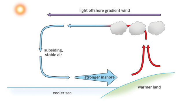
Figure 1 How a basic onshore breeze is created at sea level
This was first developed by David Houghton and Fiona Campbell, both hugely experienced forecasters for sailing events from the Olympics to the America’s Cup.
The quadrants are defined by the way the gradient wind is aligned with the shore.
If you use the shoreline as a reference while looking towards it (see Figure 2), then Quadrant 1 (Q1) is from your port bow, Q2 your starboard bow, Q3 your port quarter, and Q4 your starboard quarter.
On the west coast of Wales, for example, a Q1 breeze would be a north-easterly. Great Yarmouth, out on the east coast of Norfolk, which has a north-south aligned coast, would have south-westerly winds as a Q1 breeze.
The gradient wind aloft is best seen by the movement of any low clouds – the wind at the surface where you are may well be affected by friction with the land and any obstructions.
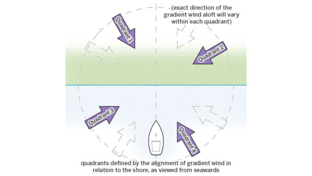
Figure 2 Quadrants are defined by the way the gradient wind is aligned with the shore
Offshore gradients
The offshore gradient wind quadrants, Q1 and Q2, give rise to different flavour sea breezes, but they are definite sea breeze cells, with the gradient wind eventually helping the sea breeze cell develop. The different flavours come from the way the wind comes off the land.
The Q1 gradient wind (see Figure 3) is usually around 30° to the right of the surface wind over land, due to surface friction slowing it down. As the wind goes over water the surface friction drops, and the wind usually veers about 15° right (this can take between 0.5 to 3 nautical miles, depending on water, land and air temperatures).
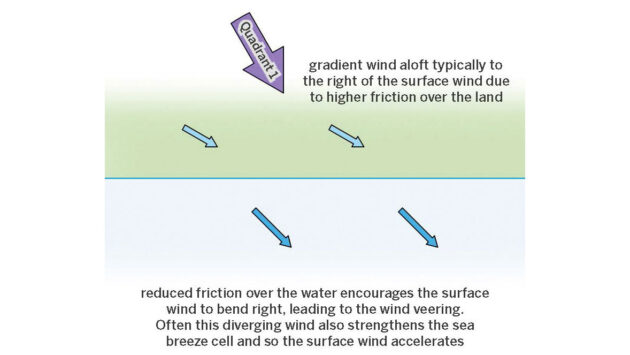
Figure 3 Q1 gradient wind tends to veer right and create divergence leading to stronger sea breezes
This gives us divergence inshore with air moving further away from the coast, and effectively creates space for air aloft to descend, helping the sea breeze cell form. This usually gives a stronger sea breeze which lasts longer too.
It will start off coming directly on to the shore, but quickly veer right and settle down to a mean direction usually between 20-40° off the main line of the coast (though this does depend a lot on local geography).
With a Q2 gradient wind showing any low clouds coming towards your starboard bow as you look ashore, as the wind goes from the high friction land over the low friction water surface it will speed up and veer right, just as before – but in this case that takes it shoreward, with convergence along the coast (Figure 4).
This makes it more difficult for air aloft to subside, and therefore the sea breeze usually takes longer to set up and is weaker. Because the convergence remains in place you may well find the sea breeze cell sets up a little offshore and doesn’t make it right into the beach. It’s important to keep an eye out for where the wind-induced chop gets noticeable less close to the beach, which is the only real clue as to where it dies off.
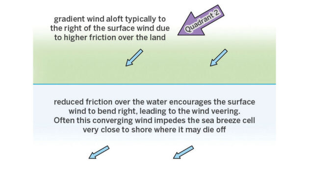
Figure 4 Q2 wind speeds up and veers right with convergence along the coast
Onshore winds
When there’s an onshore wind from either Q3 (port quarter as you head into the beach) or Q4 (starboard quarter) it’s already quite difficult for a sea breeze to develop, as the upper part of the cell – the one that takes the air back offshore – has to overcome the gradient wind.
So if you do get a sea breeze cell developing it only happens if the onshore wind is light, and often you’ll get a complete drop-off before a weak and usually fairly short-lived sea breeze sets in.
What’s more likely to happen is the onshore gradient wind itself becomes thermally modified.
A Q3 gradient wind will often lead to thermal enhancement, which can turn a light breeze into a lovely one, and quite quickly too (Figure 5).
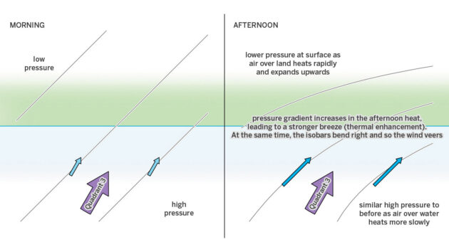
Figure 5 A Q3 gradient wind can often be thermally enhanced from a light breeze into a stronger one
Buys-Ballots law states that in the Northern Hemisphere if you stand with your back to the wind the low pressure side of the pressure gradient is to your left.
This means that the low pressure side is on land, the high pressure side at sea. As the day warms up the land will heat up more than the sea and as it warms the air above it will expand, causing the barometric pressure to decrease.
The pressure over the sea will stay much the same however, due to the much smaller temperature rise. This means the pressure gradient increases, so the wind also increases.
At the same time the isobars bend right, so the wind also veers. This effect often happens around 1400 local time, and doesn’t take more than about half an hour. I’ve seen a thermal enhancement of 12 knots to 18 knots, and a veer of 20-30° – it really does enhance the wind.
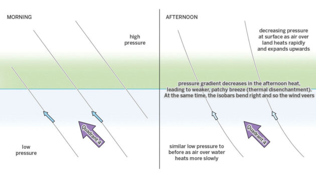
Figure 6 A Q4 wind affected by ‘thermal disenchantment’ can become light and patchy
Q4 frustrations
Q4 wind is another kettle of fish. This is known as thermal disenchantment in the British Sailing Team, and can lead to a frustrating afternoon of light and very patchy wind (Figure 6).
With the wind coming from your starboard quarter as you head into the beach, Buys-Ballot’s law tells you the low pressure side of the pressure gradient is to your left, out to sea, and the high pressure side over land.
As usual the land heats up faster and more strongly than the sea surface, and as the air over the land expands the barometric pressure decreases. This means the overall pressure gradient also decreases – the low end over the sea is much the same, but the high end over the land has become not so high.
This means the wind speed drops off and, in theory, the isobars also bend to the right causing the easing wind to veer. In practice what usually happens is that it goes very light and patchy, with local thermal effects (for example, an enormous car park or airport near the beach bringing a very local sea breeze cell in) becoming much more important. It’s a better idea just to stay offshore in these conditions, where the breeze is usually both stronger and steadier.
Whichever quadrant develops during the day it’s almost certainly not going to be entirely cut and dried, as there are few locations where the coast is straight for miles with a nice sloping beach as opposed to steep cliffs or valleys. But by applying quadrant theory to the overall situation you can get a better idea of what you’ll get during the day if you’re sailing inshore.
 If you enjoyed this….

Yachting World is the world’s leading magazine for bluewater cruisers and offshore sailors. Every month we have inspirational adventures and practical features to help you realise your sailing dreams.Build your knowledge with a subscription delivered to your door. See our latest offers and save at least 30% off the cover price.
Note: We may earn a commission when you buy through links on our site, at no extra cost to you. This doesn’t affect our editorial independence.