




Simon Rowell explains everything you need to know about the development of sea breezes
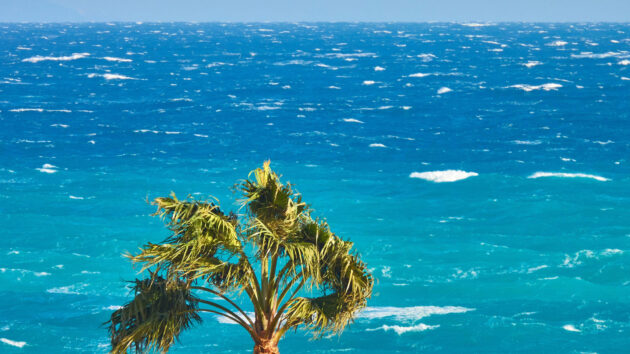
Sea breezes are the sailor’s saviour on hot, still summer days when the country is sitting under an enormous high pressure system with very little overall pressure gradient.
As the sun’s energy reaches the surface it’s absorbed by both sea and land, but because the land is solid this energy only reaches the top metre or so (depending on the exact nature of the surface) and therefore the land warms more than the sea (we’ve all had “Ow, ow, ow!” moments running across the beach).
During the morning the land will heat up – a rise of about 3-4°C more than sea surface temperature is sufficient to get it going – and by mid-morning the air above the land will have started to warm up and expand.
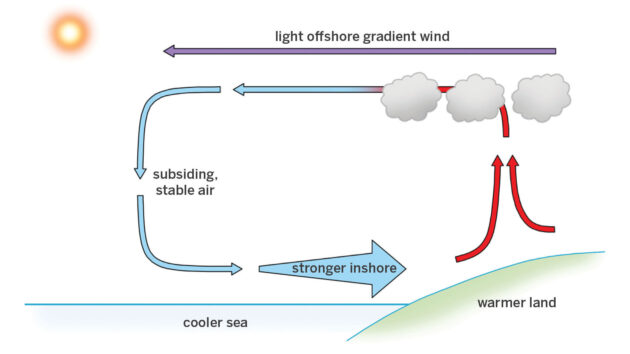
Figure 1 shows how heated air over land moves out to sea then cools and returns as a sea breeze
As it does so it can only go one way – that’s up and out to sea (see Figure 1, above). It can’t go inland because the air there is also expanding. This movement of air away from the land means there’s physically less air above the surface along the shore causing a localised low pressure onshore.
The air moving out to sea cools as it passes over the cooler sea surface and adds to the air there, forming a localised high pressure offshore – now we have a circulation going.
If there is a gentle offshore geostrophic wind above the surface this helps matters along. As the temperature difference between land and sea increases, so does the strength of this cell.
The cell itself will extend quite some distance offshore – it’s been reported out to nearly mid-Channel off the south coast of the UK, and up to 100 miles in the Red Sea. But however far it goes, it’s always going to get stronger as you approach the shore, because the returning air can subside at any point off the beach and it’s a cumulative effect as it comes ashore.
Cloud-spotting
Modern high resolution forecast models are getting much better at predicting this fairly local effect. If conditions are marginal, however, then looking at the progression of clouds from late morning can help enormously to see whether it’s coming in or not.
Every year in late March the British Sailing Team heads out to Palma for the Trofeo Princesa Sofia Regatta, the first big European event for all the Olympic classes each year.
It’s early spring then, and can be quite cold, so even with a light offshore northerly blowing it’s a marginal call for a sea breeze. I’m always nervous about this (if I’m wrong it means being about 180° off in forecast wind direction, which is never good) so I monitor the cloud development closely.
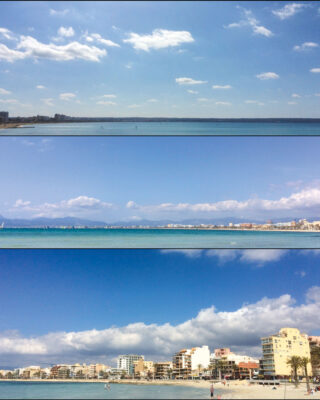
Figure 2 illustration of typical sea breeze cloud development over Palma, Mallorca, in early spring
The photos (Figure 2, above) show late morning scraps of cumulus humilis bubbling up over land, which is always a good sign, and then by noon the sea breeze is in with sea breeze cumulus building up just inshore.
These clouds build and move inland (sometimes called a sea breeze front) and reach their largest around 1400 local time. They are fed by the moisture coming back in with the sea breeze, and so when you see them start to get a little smaller later in the afternoon it’s an indication that the whole sea breeze cell is weakening.
Veer or back?
Usually the sea breeze will start coming in perpendicular to the line of the coast, and then the Coriolis effect will come into play to make the direction veer right in the northern hemisphere (and back left in the southern). The amount it veers or backs will depend on local factors such as the shape of the coastline and nearby peninsulas or bays. Every location does tend to have its own settled sea breeze direction.
The onshore component of the sea breeze is quite shallow and therefore gust patches tend to be small, weak and mostly going with the flow.
There’s a small, short phase oscillation left and right of the mean, usually +/- 5-7° every 2-3 minutes. However, in the strongest period of the sea breeze cell – say 1400 to around 1700 local time – there is often a long phase oscillation.
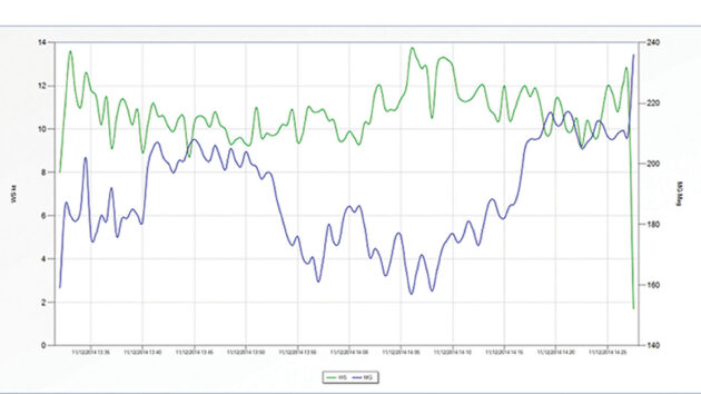
Figure 3 wind trace image from the harbour in Rio de Janeiro illustrates oscillation every 15 to 20 minutes
The example shown (Figure 3, above) is from the harbour in Rio de Janeiro and the blue wind direction curve shows a 40° shift left then back right again with a 15 to 20 minute period. The wind speed also changes but this is usually not anywhere as significant as the wind shift. This effect is usually noticeable once the sea breeze has set in properly, and is often limited to the strongest 2-3 hours of the cell’s life.
While it’s true the sea breeze usually starts off perpendicular to the shore this gets more complicated when there are multiple shorelines involved. The Solent and Tor Bay are good examples of this, but an even better one is out in Greece, at Thessaloniki which was the venue for the 49er, 49erFX & Nacra 17 European Championships in June 2025. This was approaching the warmest time of the year with land temperatures often in the 30s.
Every morning there was a sea breeze that started off heading onshore all around the Bay, but by about noon the main flow from the Aegean into the Bay, across the approximately north-west to south-east aligned coast, came in and built.
If you are looking at sea breeze in a bay then this is often the case – the very local thermal effect will start off around the shore of the enclosed bay, and then a little later the main sea breeze draw across the main line of the coastline will take over.
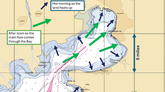
Figure 4 in Thessaloniki localised thermal effects in the morning give way to a main sea breeze later
Stay in phase
The sea breeze has saved many a day on the water, so if the forecast is for a hardly any pressure gradient and sunshine then start looking for small puffs of cloud bubbling up by late morning, and if they do then flags and banners along the shore should start fluttering inland soon after.
If you’re racing, keep an eye on the numbers and try and hook in to that long phase oscillation; if you’re just messing around on the water (an equally valid use of a sea breeze day!) then every now and again watch the cumulus clouds lining up just inshore, and when they start to get a little smaller you know the breeze will start to drop.
 If you enjoyed this….

Yachting World is the world’s leading magazine for bluewater cruisers and offshore sailors. Every month we have inspirational adventures and practical features to help you realise your sailing dreams.Build your knowledge with a subscription delivered to your door. See our latest offers and save at least 30% off the cover price.
Note: We may earn a commission when you buy through links on our site, at no extra cost to you. This doesn’t affect our editorial independence.