
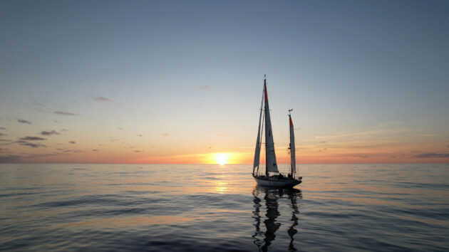
Think the tropics are just lines on a map? Think again. Here is how solar radiation, trade winds, and melting butter define the zone
What actually constitutes ‘the tropics’? Navigationally it’s easy to define: the tropics lie between the Tropic of Cancer at 23° 26’N and the Tropic of Capricorn at 23° 26’S, which mark the northern and southern limits of the sun’s travel.
A better way of looking at it is to think of the energy arriving from the sun. The heat supplied to any point on earth by the sun depends fundamentally on its latitude, and the amount of heat reradiated is determined by its surface temperature.
As the equatorial latitudes receive more heat than the polar ones this leads to an imbalance. The tropics are thus the part of the Earth’s surface which receives more solar radiation than it radiates back out. The tropical systems and ocean currents act to transport this heat away from the tropics towards the poles – if this didn’t happen the tropics would keep getting hotter, and the poles would keep getting colder.
This leads to a basic meteorological definition of the Tropics – the regions between the sub-tropical ocean highs and the equator, approximately 30°N to 30°S.
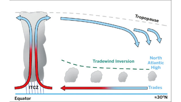
The North Atlantic Hadley Cell, from sea level to the tropopause, the transition zone between the troposphere and the stratosphere
Hadley Cell
The main system transporting heat away from the tropics is the Hadley Cell, a large circulation on each side of the equator between the equator and the centre of the mid-ocean high.
Looking at the North Atlantic Hadley Cell in more detail (Figure 1, below) it can be seen that the excess heat of the tropics is taken away vertically by rising convection in the Intertropical Convergence Zone (ITCZ), and then taken polewards by the upper level winds. By about 30°N the air no longer gets enough heat from the surface and cools more, becoming denser and subsiding towards the surface to form the North Atlantic High.
This descending dry air forms an inversion stopping the surface heating and convection from rising any further, which effectively puts a lid on the tradewind clouds. The surface tradewinds themselves blow in towards the ITCZ picking up moisture along the way.
The air here is generally much warmer than in the mid-latitudes, and can therefore absorb more water vapour. This means that if the relative humidity is 90% in the tropics there is significantly more water in a given volume of air than if it were a relative humidity of 90% in Europe or New Zealand.
The net result of this is that when it rains it really rains, and there is far more moisture and energy in tropical weather than in mid-latitude weather. Keeping shampoo on deck is a good idea!
10m winds (knots) and mean sea level pressure (2mb isobars), for 17 February 2026. Photo: c/o Rowellweather,com
Tradewinds
The trades are driven by the pressure difference between the mid-ocean high and the ITCZ with the Coriolis effect bending them to the right (Figure 2). The bigger this pressure difference, the stronger the trades. This brings the first big conceptual difference for predicting tropical weather – the ITCZ stays at pretty much the same pressure, it doesn’t vary a lot.
Therefore the strength of the mid-ocean high is what drives the strength of the trades, and the higher the pressure, the stronger the wind – if you’ve done a lot of middle latitude sailing this takes a while to get used to.
In the North Atlantic the tradewinds are usually picked up south of the Canary Islands at about 25°N, and there’s a grain of truth in the easy way to navigate to the Caribbean: ‘go south ‘til the butter melts and then turn right’.
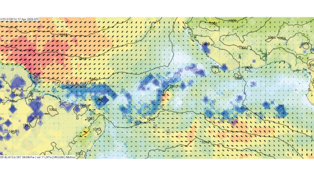
The ITCZ with mean sea level pressure (2mb isobars), wind (knots) and rain (blue shading) for 17 February 2026. Photo: c/o Rowellweather,com
An important point is that the tropics mainly have one air mass so the whole concept of weather fronts doesn’t normally exist. Because the Hadley Cell and therefore the trades are strongest in winter there are frequent occurrences of deep low pressure systems polewards of the high dragging cold fronts over the tropics.
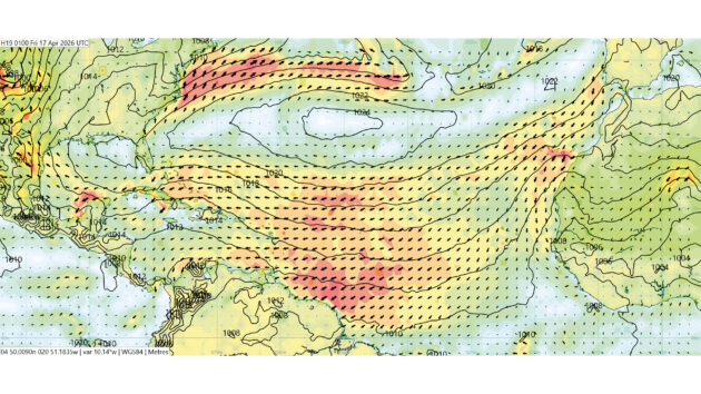
The trades are generally quite steady, but if a deep low moves equator-wards this can both push the high south and trail a front down to the tropics, both of which will severely affect the trades. Figure 3 shows how the low at 36°N 029°W trails a front down to the SW and this effectively splits the high. The trades are knocked right down ahead of this front, with light and variable wind there. As an aside, this illustrates the use of precipitation data (the blue shading) to show fronts.
The doldrums
The ITCZ, also known as the doldrums, has an undeserved reputation as being a windless hole where nothing happens. Sailing through it is hard work, as the wind comes from all directions and can vary greatly in strength, potentially leading to expensive mistakes with lightweight sailcloth. This is the zone where the two Hadley Cells meet, and at the surface this is where the north-east trades converge with the south-east trades.
In the North Atlantic the ITCZ varies from just north of the equator in December to about 10°N in July and August. Figure 4 shows that in the North Atlantic the ITCZ tends to be widest near the West African coast, and it can be seen here that as it’s further to the north the south-east trades are bent to the right by the Coriolis effect as they cross the equator, ending up as south or south-west winds by the time they converge into the ITCZ.

The North Atlantic has a low at 36°N 029°W, and trails a front down to the south-west, effectively splitting the high in two. Ahead of this the trades are disrupted (red outline). This has GRIB data for wind (arrows) and rainfall (blue shading) overlaid onto a NOAA synoptic chart. Photo: c/o Rowellweather,com
As you approach the ITCZ, a sign you’re no more than a day away from it is the sight of high wispy cirrus clouds going the opposite direction to the surface winds you’re sailing in.
The ITCZ is not a uniform wall of convection and cloud. It varies in both width and direction – whether it’s moving north or south. It can be anything from 50 to 300 miles wide. You may not have the choice, but the ideal scenario is to cross the ITCZ when it’s going the opposite direction to you, ie north if you’re south-bound, or south if you’re north-bound. A good level of vigilance is required going through it, as there is no prevailing wind and everything’s squall driven, so what is your leeward side one minute may be the windward side the next.
But in general sailing in the tropics is a joy – it’s warm, the weather’s mostly steady and there are lovely places and people to visit. The increased heat and humidity does mean that weather can change quickly and suddenly, making a regular look at the forecast more important than ever.
 If you enjoyed this….

Yachting World is the world’s leading magazine for bluewater cruisers and offshore sailors. Every month we have inspirational adventures and practical features to help you realise your sailing dreams.Build your knowledge with a subscription delivered to your door. See our latest offers and save at least 30% off the cover price.
Note: We may earn a commission when you buy through links on our site, at no extra cost to you. This doesn’t affect our editorial independence.