
From alligators to turtles to wild horses, and many, many birds, Tom Zydler found a coastline teeming with wildlife in the creeks and ‘hammocks’ of Georgia, USA
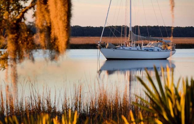
I felt the urge to roar “Ho, ho, break out the grog boys, this is it!” but it wasn’t 1720 and there was just Nancy and me. Our Mason 44, Frances B, was heading into a narrow river on the west side of Blackbeard Island in the middle of the Georgia coast on the Atlantic Seaboard of the US.
Blackbeard Creek slaloms south before spilling into the Atlantic eight miles later. With the help of high tide we slipped over the bar and anchored in a deeper pool, so hidden behind dense forest no one could spot us from the ocean. Or from the west where more high trees rose on Sapelo Island. We had found a perfect hideaway.
Three centuries ago, before colonial loggers cut the old forests and the mud began bleeding towards the sea, this creek would have been deep enough for good-size ships. Though, but for the persisting name, there is no firm evidence that Edward Thatch or Teach, known as Blackbeard, the self-employed robber of ships, stopped here.
The name Blackbeard Island first appeared on a survey map in 1760, four decades after Thatch’s severed head swung from the bowsprit of a British Navy ship. In 1924 the island became a federal wildlife refuge.
Tresses of hanging moss at Blackbeard island
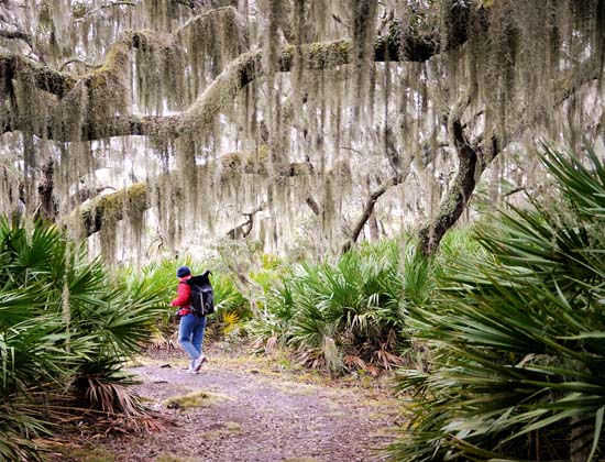
Our reconnaissance dinghy ride ended at a floating dock covered with otter droppings, tangible proof of the thriving wildlife. The trails ashore led into the shadows of a dense forest, the branches curtained with witches’ tresses of Spanish moss.
Deer and armadillo
Common in the American south, their exceptional length here advertised clean air since the plant, an epiphyte, is sensitive to pollution. Now and then a deer scampered away, white tail flagging among trees. Startled by noisy rustling off the trail’s side we tracked an armadillo nosing through layers of leaves. A silent owl in feathers the colour of the leafy backdrop dozed, although its round yellow eyes followed our passage below. The trail spilled over onto the beach onto a tangle of fallen oaks and palmettos.
Clusters of small oysters covered the roots at the water’s edge. Not a trace remained of the quarantine wharf where ships bound to Savannah for rice or to Darien for timber had to stop. In 1909 the yellow fever vaccination proved effective and the station closed. On our January visit only bird tracks, scattered sea shells and the skull of a porpoise etched 12 sandy kilometres of Atlantic beach.
 Of the 17 barrier islands on the Georgia coast only four have small permanent populations. We began scouting for real wilderness on the way south, after the busy Savannah River ship channel vanished in haze. Shoals less than 2m deep spoil the wide mouth of Ossabaw Sound, often building dangerous breakers with the arrival of high Atlantic swells. But we sailed in on calm sea and the tide was rising. A line of tall pines drew the jagged skyline of Wassaw Island to the north.
With a forecast of strong northerlies Wassaw Creek, protected by marshes on its west side, would make the best anchorage. The trees on the young (geologically) Wassaw Island have always grown tall, yet too slim to have attracted loggers. The island, owned privately as a hunting retreat, sold in 1996 to the Nature Conservancy, which then passed it to the federal government for US$1.
While wandering the trails you might get a glimpse of a white mansion at the end of an avenue of gnarly oaks – the previous owners retained a parcel of land. Sometimes the students of oceanography show up on field trips. Volunteers come in May to protect loggerhead turtle nests from roving raccoons. However, in autumn and winter the shorebirds have it all.
Eight-mile beach
Reaching Ossabaw Island, only four miles south, required a dogleg seaward to pick up the deep water channel. Bradley River, where Frances B anchored, undercuts the high dunes – the beginning of a blazingly white eight-mile beach. Nesting sea turtles – the true ocean voyagers – loggerheads, leatherbacks, green and lately even a few olive ridleys love it.
The bulky Ossabaw Island on the west side of Bradley River was used for ranching animals in the past. Only donkeys and feral pigs remain though actively culled pigs have recently become less of a threat to turtle eggs.
Here, too, volunteers guard the nests between May and September. When, in the middle of winter, high Atlantic swells penetrated the sounds leading in from the ocean, we headed west into the shoal-plagued Intracoastal Waterway.
But the tidal ranges in Georgia vary between 1.8m and 3.3m so Frances B moved over shallow spots on the rising tide and anchored before tides ran too low. With the dinghy we penetrated tight streams sending aloft schools of migratory shore and water birds.
Cane Patch Creek on the west side of Ossabaw Island winds past densely tree-covered islets, ‘hammocks’ locally. Buckhead Creek just around the corner led us to a shore where vines took a tight grip on old slave houses built of ‘tabby’, a mixture of oyster shells and lime common in colonial times.

Frances B hidden in the marshes of Buckhead creek
Nearby some wooden structures marked an extinct hippy commune of the 1970s. The mid-day sun brought out an alligator. A dozen night herons colonised the hammocks surrounding the anchorage.
St Catherine’s Island next south is unusual. Its owner, a private foundation that breeds endangered animals – the ring-tailed lemur among others – has put the island off limits to private visitors. It stands on the grounds of a previous Guale Indians’ village, Spanish monks’ mission, Georgia white plantation owners and the quarters of Tunis Campbell. Campbell collected slaves freed by General Sherman at the end of the Civil War and formed an army of 250 men.
His project failed after white Georgians recovered from the Civil War. The hurricane of 1893 completely washed over the island, yet today it looks primordially wild.
With Frances B secure at anchor in Walburg Creek along the west shore of the island, we planned to take full advantage of the Georgian law that beaches are free to roam by all. We never managed to walk all of them.
Bizarre horseshoe crabs
Spring low tides bared a fantastic stretch of sand banks in St Catherine’s Sound. After splashing through ankle-deep water we had a couple of hours studying the shells of whelks, cockles and angel wings and chasing painted olives – molluscs – escaping head first under the wet sand. It felt thrilling to stand in the sea a mile away from rows of tree trunks, branches and roots undermined by tides, contorted and twisted as if in agony.
The long shores of St Catherine’s (and other islands) bring in bizarre horseshoe crabs to mate. About the size of a wash bowl, equipped with nine ‘eyes’ all over the carapace, as a species they have been around for half a billion years, predating dinosaurs. They are true bluebloods – their blood, tinged blue by a high copper content, also contains mobile cells that detect and destroy pathogens.
Sailing across Doboy Sound, we were passed by only one vessel, a ferryboat on the way to the southern end of Sapelo Island populated by some 40 descendants of Gullah-Geechee plantation slaves. There is also a marine wetlands research station and tobacco magnate R. J. Reynold’s old mansion turned into a guest house. Thousands of migrating birds stop in the tall grasses near the lighthouse.
Doboy Sound was very different during the 19 Century timber boom when dozens of ships anchored between the islands waiting for a free wharf in Darien, a small town up a tidal river. In those days Darien could load 20 ships a day.
Now Darien slumbers, home to a shrinking number of shrimp trawlers, small compared with the grand windjammers that carried Georgia’s long leaf pine and cedar worldwide. A few miles south of Darien River Frances B began furrowing through swirls of thick brown mud from the undammed Altamaha River, once a waterway for rafts of timber on the way to Darien.
Largest of the barrier islands
Over 13,000 people live on St Simon’s, the largest of the barrier islands, built over with a lot of upscale development and giant private homes. However, even when searching for wilderness, you’d be wrong to dismiss visiting here.
Hampton River cuts east along the north shore of St Simon’s Island. Miles of marshes spread out, like sea prairies, along the river’s north banks, an intact world of birds, otters, mink and dolphins. Swinging left and right between beacons, we passed a marina, some housing, a densely wooded uninhabited point on the main island and soon plunged into Pine Creek, an oxbow off Hampton River.
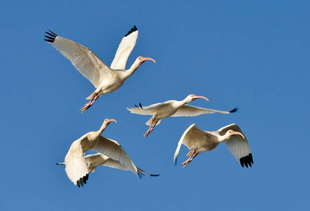
Three glossy ibis winged overhead, snowy and reddish egrets punctured the mudbanks for food, an extended family of hooded mergansers paddled away, a haunting loon’s call echoed off the forest on Pine Island by the anchorage. A wood stork, black-headed with an enormous wingspan, hovered over a deeper pool on the almost flooded upland.
Exploring Pine Island, we pushed through a thick growth of fan-shaped, sharp-ended scrub palmettos, by twisted oaks, pines, some tall, some down in rotting pieces. Edges of crumbling oyster shells stuck out from humps of dry soil – ancient middens left by foraging Guale Indians. The din of cackling ‘marsh hens’, clapper rails, resounded in the spartina marshes as the sun went down.
Quite a different aspect of St Simon’s unfolded as we sailed down Frederica River along the west side of the island. About midway southward Frances B slid unmolested by the guns of Fort Frederica, General Oglethorpe’s 1742 bastion of English presence against the Spanish. Arriving with an armada of 36 ships, the Spanish landed a few thousand men against about 1,000 English and Indian allies.

After the English prevailed a town grew up around the diminutive fort. Large homes hide in the trees on island banks of the river while across from them marshes breathe with tides, intact.
A mile south from St Simon’s is Jekyll Island. The 19th and 20th Century financial heavy-hitters of America – the Macys, Astors, Goodyears and Vanderbilts – created the very private Jekyll Island Club. Winters brought grand steam yachts, among them Pulitzer’s 250ft Liberty. Good times ended with World War II.
Historic District
In the 1950s the state of Georgia bought the island and put convicts to building a causeway from the mainland across the marsh creeks. Disturbed natural water flow silted Jekyll Creek into a mud bath, a thread of water in its middle only a metre deep at low tide.
Too many motels sprang up along the shores, quite a few now abandoned as hollow-eyed shells. The Jekyll Club and some of the giant ‘cottages’ of the wealthy along the west shore remain as the Historic District.
A small marina cosies up to the bridge over the Waterway. Birds still like the place. Avocets swing their upturned beaks through mud. Greater scaups, seagoing ducks, come in flocks when the Atlantic boils up in a gale.
We took the deep water trench off Jekyll’s southern point and came within spitting distance of a thick flock of black skimmers, powerful flyers that rest on land on ludicrously short legs; with a few pairs of oystercatchers and many terns, they tolerated our close- quarters gawking.

You must admit the very wealthy of the Gilded Era had a talent for finding the best islands. Around 90 per cent of Cumberland Island, at 32km the largest of Georgia’s barrier islands, was once owned by Thomas M. Carnegie’s family, using three large mansions – one now a posh hotel.
Cumberland Island National Seashore is today protected from development, a status declared by President Nixon in 1972, just in time to save it from an investor who, flush with profits from development of an island in South Carolina, planned subdivisions joined from the mainland by a ski lift over 5km of wild marshes and deep tidal rivers.
High dunes
We anchored in Brickhill River off a low bluff. Only kayakers and some hardcore hikers camped there after walking four hours from Sea Camp, the park headquarters and ferry landing farther south. A trail to the Atlantic beach brought us to the dunes, some 15m high. Roots of palmettos, the trees long gone, held together cone-shaped hillocks prominent among sweeping valleys of sand.

The line of high dunes runs down the east shore of Cumberland. Stormy onshore winds moving dunes inland shape the native live oaks into enchanting forests, their twisting long limbs crawling low for 15 to 20m, farther than the heights of the parent trees awash in sand. Among them we felt surrounded by animate creatures.
The shaded trails on Cumberland run under a canopy of leaf fabric veined against the light by spidery oak branches locked together. The trail across the island from Sea Camp opens upon the widest beach we had yet seen – for at least as long as the spring low tide lasted. At the lip of the sea stood a family of feral horses, with an awkward colt on stiff stick legs. On this early morning they probably enjoyed the cool insect-free air as much as we did.

The author
Tom Zydler is a marine author and photographer, who has written many articles and cruising guides. He and his wife Nancy sailed round the world via South America and Antarctica in their yacht Mollymawk