
Route planning isn’t purely about finding the quickest route from A to B. Pip Hare shares her top tips on how to sail quickly and comfortably

Most of us now rely on some form of routeing software when sailing offshore. These packages calculate the fastest theoretical route between two points based on polars and predicted wind, using an isochronal method. The software assumes we’ll sail the boat to its maximum potential, taking every wave on the chin. This can result in a route that may be fast but is also brutally unsympathetic.
To plan a more comfortable route we need to set out our own parameters for acceptable conditions. These parameters will change with crew numbers and how heavily loaded your boat is. By manipulating the data with which our routeing is calculated, then comparing results, we should be able to plan a much smoother ride.
Polars
A realistic set of polars is key to good routeing, especially when trying to avoid weather systems. There is an impressive variety of polars for cruising boats included with most routeing packages, but these should be only a starting point – seldom will you be sailing the boat at 100% of its theoretical performance.
Use the percentage polar feature to adjust your performance, being as realistic as possible. If trying to stay ahead of a weather front, run a couple of routeings with lower percentage polars to double check the implications of sailing slower than predicted.
If your routeing software allows the input of different polars for different conditions, then it is well worth taking the time to build these up.
Max wind strength
Almost all software will allow the input of a maximum wind speed along the route. The speed you select should take into consideration wind angle, loaded weight, crew experience and your sail wardrobe.
If your software allows the input of different wind strengths for different points of sail, then give it as much to work with as possible. If not, set for the maximum wind strength upwind, run a trial routeing and check the table of legs: if the whole route is downwind, you could increase your maximum wind strength then run another route.
When setting your limits remember that in the average frontal system you may expect gradient winds of 10% more and gusts of 25% more than the forecast 10m wind. Some software will allow you to increase the gradient wind to 110%. If not then, decrease your max wind strength by 10%.
Once your route has been calculated, check the table of legs for any areas of concern – you may end up with several legs in one knot less than your maximum wind strength. Overlay a gust map on your route. If this is not available, a precipitation layer should help identify frontal systems where the gusts will occur.
Minimum wind strength
When making a long passage fully laden, adjust your polars to reflect the extra weight on board – which will be especially detrimental in lower wind strengths.
Beware the optimism of routeing software around high-pressure centres; once the route is calculated overlay a MSLP (mean sea level pressure) chart and check you’re not being sent through the centre of a high.
Check the table of legs for boat speed against wind speed. If you think the route optimistic, it probably is. Increase your minimum wind strength by five knots and see if the route changes.
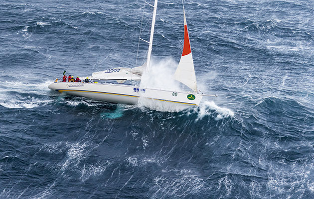
Significant wave height
Expect to encounter many waves that are smaller than predicted and some significantly larger. Breaking waves can be considered to be dangerous when the wave height is over one third of the length of a boat, for example, 4m waves breaking on a 12m boat.
When setting your limits for significant wave heights don’t just think about what is dangerous but consider what is appropriate. Take into account the wave period: the most uncomfortable seas will arise from shorter wave periods combined with larger wave heights.
If your routeing package doesn’t allow you to specify maximum wave height, check a specialist chart against your route – then try setting waypoints to route away from areas of concern. Particularly take note of conditions following periods of sustained high winds, when the wind strength is less but the waves could still be large.
Article continues below…

Video: 6 of the best heavy weather sailing videos
This first video of heavy weather sailing is our from our Storm Sailing Series with Skip Novak. It was probably…
How to cope with stormy weather by top French sailor Loick Peyron
Weather like this during the Sydney-Hobart is not a surprise for the guys who start the race. They know what…
Wind direction
When coastal sailing, the wind direction in relation to current and the geography of the coast will have a huge impact on comfort. Do not expect your computer to interpret these conditions; these are often situations when the fastest route is the most miserable.
Consider the sea state that will be caused by wind over tide conditions, overfalls or onshore waves against large cliffs. Set up waypoints or no-go zones to keep away from shallow water or tidal races.
When offshore check the wind direction against the direction of the swell. The most uncomfortable seas can occur when these are at odds. In particular beware of the wind shift after the passing of a front, when sudden and dramatic changes to wind direction can cause dangerous breaking seas.
Your strategy
Short-term strategy (1-3 days) is often about picking the right departure times and taking into account the coastal effects. Don’t be tied to a departure date.
Long-term strategy will be negotiating larger systems and it’s good idea to use surface analysis charts to make decisions about this, as well as relying on a computer. Always compare several versions of your route, changing the parameters, especially polars. If you don’t like the resultant routes, use waypoints to force a change.
Medium-term strategies (3-5 days) can be the most challenging: too far from land to seek a port of refuge and often determined by the passage of frontal systems. If it really appears necessary to take some short-term pain for the long-term gain then set the isochrones to short intervals (1 hour) and thoroughly check the table of legs for areas of concern.