
The variables involved in accurate weather routeing are many and it's easy to get confused with all the packages available. Pip Hare tests five popular programs to assess their usefulness
Tested: Pip Hare tries out five of the latest weather routeing packages
Every discerning sailor will carry out some sort of weather routeing before going out on the water. The extent to which we are able to predict weather patterns and assess our own boat’s performance relative to it is getting better and better as computing power develops. This is an involved and intricate science, but it is being made more readily accessible to all sailors.
The variables involved in accurate routeing are many and it is easy to get sucked into an information overload when you start investigating what today’s computer-driven weather routeing can do. If you choose the right product for your needs, however, these are powerful aids that are essential to help you plan a safe, quick and comfortable passage.
I picked five popular weather routeing options available today to compare their key features and assess how easy they are to use.
5 weather routeing packages tested
Professional subscription available online or via a PredictWind Offshore app for mobile platforms. The subscription price is £179 for three months or £399 per year.
An Android-based app that currently costs just £35 for an indefinite licence.
Software package costing US$1,295 (£901). Its Tidal Atlas for North Western Europe is an extra £175.
Free software package that can be downloaded to a Windows PC or the Squid mobile app for tablets/phones. I tested the racing CEP 0.125 subscription at €605 (£459) per month.
I tested the TZ Navigator pack with advanced routeing and current charts for the UK and Ireland, which costs £859.
Choosing a model
In simple terms, the computer programs that produce our weather forecasts use current weather observations applied to mathematical models to predict future conditions. Different models can produce strikingly different predictions at times and in my experience most people develop a couple of ‘favourite’ models they consider to be the most reliable. It is always worth comparing routeings from more than one model and so as a start I looked at what models were on offer from each of our routeing options.
The available models can be broadly split by resolution, model type and geographical areas covered. The higher-resolution models offer more detail and a greater degree of accuracy, but for a smaller area. It is often useful if making a trip offshore to blend a high-resolution file for departures and arrivals with a lower resolution one for information offshore.
I found all of the program menus reasonably easy to navigate when selecting weather options – it just takes a bit of trial and error to understand which model is best to use when.
PredictWind has taken some of the angst out of choosing your weather model by offering only four forecast models, two of which are high-resolution ones exclusive to PredictWind users. If you are really put off by all the choice, MaxSea has a ‘weather wizard’ which will guide you through downloading a free weather file, cutting out jargon by asking you simply if you want the data from Europe or America and then ‘accurate data’ or ‘normal data’ for resolution.
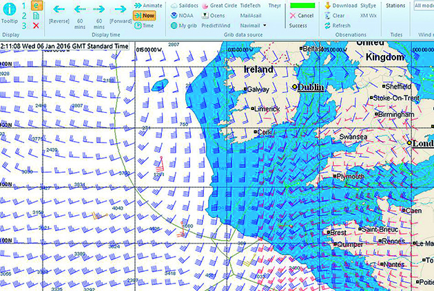
Downloading and viewing more than one GRIB file at the same time will enable you to compare models, or blend higher and lower resolution files. Squid, which is essentially a GRIB viewer with routeing capability, does this incredibly well, though you do need to work on the configuration of colours and arrows to get the right balance of information.
Expedition also allows you to view multiple forecasts together, although with fewer visual options. Squid and PredictWind GRIB files can also be viewed in Expedition software.
Expedition showing a high resolution forecast with current wind observations laid over
Observations and real-time information
Being able to load and view real-time weather data against your downloaded forecast is a vital tool on passage; I use it most often to check the progression of a front or around areas of high pressure.
Squid has the most exciting offering in this area with its ability to download satellite images, synoptic charts, SCAT files (satellite wind speed observations) and weather observations at the click of a button. Normally I go to three or four different sites on the internet to find this information so to have it all accessible through one platform is very handy.
There is also a beautiful feature that allows you to play a route with the satellite image and selected GRIB files overlayed; you can then move either the GRIB file or the satellite image in time. This visual and easy to use tool allows you to match up real-time weather data and your own forecasts accurately to help understand whether systems are moving more quickly or slowly than anticipated.
Expedition has observations from buoys and ships, as does PredictWind, but neither SailGrib nor MaxSea offer real-time weather observations.

MaxSea displays tide using coloured arrows to indicate strength. These can be turned off
Tide and ocean currents
The subscriptions I tested from Squid and PredictWind included tidal data, but that only comes with the more expensive packages. For Expedition and MaxSea, a tidal package must be purchased – this could be either a one-time purchase of tidal atlases for geographical areas, or, with Expedition, a subscription to the tidal GRIB service Tide Tech (included with the PredictWind professional subscription).
This is essentially a hidden cost so ensure you remember to factor it in when making your decision, as in many places in the world there is little point in running a routeing without the tidal information.
SailGrib offers tidal information as standard, although the developers do state that the tidal forecasts are ‘indicative only’.
All programs tested will also download ocean current GRIBs for free and use them if selected for routeing.

Routeing options/parameters
Routeing options and parameters are a crucial step to obtaining a sensible routeing. Across the programs tested there were many options that were either easy to find or hidden away in unintuitive menus.
PredictWind and SailGrib were both comprehensive and straightforward to navigate. PredictWind asks up front if you want to route for comfort or for speed – choosing comfort will allow you to define maximum wind strengths and wave heights, while choosing speed will unlock another set of options. These include the creation of wave polars to adjust your boat speed by a percentage for waves of different heights and angles.
SailGrib walks you through a series of well laid-out parameters including the option to route for decreased efficiency at night – which none of the other programs offer. This seems to me inspirational, especially as you might choose not to fly a spinnaker at night.
MaxSea routeing options are not, like the others selected, shown as tick box options before every routeing, but are found in the general ‘options’ menu set apart from the routeing tool bar. There is a comprehensive range of options available such as scaling up the wind forecast, shifting the GRIB in time and scaling up or down your polars, but this menu is not easy to find. (above: MaxSea run route)

Predict Wind automatically offers routeing from its four standard models
Multiple routeings
Being able to view or even run multiple routeings from different models at the same time or use different routeing parameters is another valuable tool. PredictWind does this with every routeing using its standard models and has nailed the presentation with clear results charts and tables.
Expedition also does a good job at running and showing multiple routes, both with its ensemble routeing feature, which will run routes using all loaded GRIB models. It will also run multiple scenarios at the same time based on difference in polars and in wind speeds, displaying all the available routes on the same screen for comparison.
Squid calculates only one routing at a time, but will display multiple routeings together. Neither MaxSea nor SailGrib will do this; you need to run different routeings and look at them separately. MaxSea offers a different approach by shading areas along the route according to risk – darker areas show where the wind is less stable and the routeing less trustworthy. I liked this idea but was not able to run a routeing that was anything other than lightly coloured.

Polars
Going on the oldest of computing rules ‘junk in = junk out’, choosing relevant polar information for your boat has to be one of the most important considerations when working on weather routeing. All the packages I looked at have a range of default polar files available to work with as a starting point.
SailGrib has the most impressive selection in its app – around 160 options of racing and cruising boats. Squid offers only a small selection of raceboats as your starting point.
MaxSea comes with no polars pre-loaded and you must download any required from its website, where there is a selection of 168 mostly cruising boats. The selection is impressive, but the mechanism of loading is a little clumsy. They can only be downloaded one at a time, saved individually on your hard disk and then opened in the main options menu.
Data while at sea
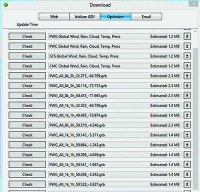
All these lovely models, images and files come at a price and satcoms data can easily blow your budget. One solution to this is to get GRIB files via email. Every package tested will allow you to do that, using the Saildocs service (email delivery of text-based Internet documents) or via their own server.
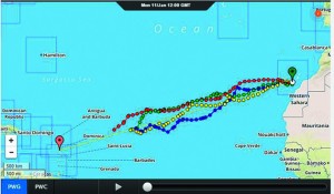
Squid and PredictWind (above) also have an offline service that allows the user to set up and request a routeing using an offline app either on a laptop or a tablet. Once the routeing parameters have been set, the app will send an email request to the main servers, where the routeing is calculated remotely.
This ‘cloud routeing’ significantly reduces data consumption by removing the need for a GRIB file. The only frustration I could anticipate was not being able to understand why a route deviates in a certain direction. Squid and PredictWind also offer neat data calculators, which allow you to see and select the size of each downloadable element for those using Fleet Broadband or a metered data connection.
If using Tide Tech for your tidal data source in Expedition, it is worth considering the cost of downloading tidal files as well as wind GRIBs – and getting the biggest file before sailing.
Programs rated
Squid 8/10
Squid is aimed at the serious racing market and you might wish to consider exactly what you are going to be using weather routeing for – do you really need a 0.03 resolution model of Le Havre? Check the subscription options and make sure you choose the right one for you.
I feel Squid’s strongest feature is the acquisition and display of meteorological data. It does a brilliant job of overlaying multiple data feeds and some of its features are just so brilliant they had me bouncing up and down in my chair.
A note of caution: my computer (Acer with Celeron processor and 4GB RAM) crashed a few times while I was testing out some of the more data-heavy features, which might become frustrating over time if you, like me, are running a cheaper laptop.
The various packages and subscriptions can be purchased month by month and scaled up or down according to your needs, which makes using Squid a very viable option. I noticed during my last transatlantic race that many of the teams were using Squid as the one stop shop for weather data, satellite images and synoptic charts, but then using that data to route in a different package.
Racing subscription €605/month
Expedition 7/10
This is not the easiest program to use. Visually it is basic and some of the menus are quite hard to get into. However, I think there is not a lot that Expedition cannot do; you just have to work hard to find out how.
If you wish to unlock the entire potential of a program like Expedition you will also need to buy tidal data, possibly subscribe to
a service that will allow you to download high-resolution forecasts and buy some charts.
Ideally it should be installed on a dedicated boat computer, then if left running and recording data every time you go sailing, it will just get better and better at finding you the way. Remember, though, to unlock Expedition’s potential you need to invest time, not just cash.
Package US$1,295
SailGrib WR 8/10
This app packs one hell of a punch and is currently the best bargain out there for weather routeing in my opinion. It has been designed and built by someone who has a passion for this subject and it shows.
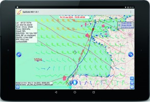
The visual representation of data is thoughtful – for instance, on routeing tables TWA on port is in red, on starboard green – and the menus are intuitive, with simple explanations to lead you through to where you need to go. It is the only package that allows you to integrate a ‘night-time’ effect into your polars.
The major downsides of this program I found was getting used to which forecast parameters would sit within the data allowance and only being able to view one routeing at a time.
This is an app that is just going to keep on growing. It is now possible to integrate open source maps. Currently Sail Grib WR is only available on the Android platform, but its designer, Henri Laurent, is planning to make an iOS version available during 2016.
In the meantime, considering its current price, it might even be worth buying a cheap Android tablet to get hold of this one.
£35 for an indefinite licence
MaxSea TimeZero 6/10
I think I understand what MaxSea is trying to do with TimeZero and that is to cut through the masses of tick-box variables that you need to put into routeing and provide an easy solution for the cruising yachtsman – but it just doesn’t sit right with me.

A typical representation of this is the update weather wizard, which cuts out so much of the jargon you have no idea what resolution file you are requesting, or from whom. I think some people might find this comforting, but I like to know a bit more about what I am doing.
Time Zero would appear to be pushing itself more towards the cruising market, as demonstrated by the impressive selection of polars available online. And you must remember it is not just a weather routeing package, it is designed as a complete navigation solution.
TZ Navigator pack £859
PredictWind 8/10
PredictWind is an entirely self-contained and neat package. The offshore app works well, is handy to use on both a tablet and a PC and I found the routeing options comprehensive and intuitive.
As with Squid, I can totally understand the data benefits of cloud routeing, but I would be more comfortable about making a weather routeing decision if I could see the GRIB file. That is something I think you could get used to in time.
You can use PredictWind forecasts in other routeing packages, for example Expedition, but the flexible subscription nature of the PredictWind and Squid services do spread the cost over time and allow you to try them out before committing close to £1,000 on a larger navigation package.
The thing with PredictWind is that if you choose it exclusively for your routeing you are restricting yourself to those four weather models – although many believe they are the best on offer.
£179 for three months or £399 per year.
Top tips for weather routeing
- Adjust your isochrones to suit the passage; 0.5 or 1 hr might be suitable for a short or inshore race, but when crossing the Atlantic six to 12, or even 24 hours, will suffice.
- Always display the isochrones while the computer is building the route – watching them build and paying attention to areas where they are close together or spread apart will help you to understand where the critical areas on the course will be.
- Download a synoptic chart before starting your routeing and sketch out with a pencil where you feel you should go – if the computer-generated forecast is wildly different, try to understand why.
- If your routeing software does not have an option for motoring in light winds, make yourself a set of passage polars which use your cruising speed under motor for every wind angle below a certain TWS – eg, below seven knots of wind the boat will travel at seven knots in every direction.
- Polars are theoretical – be realistic about the weight of your boat, the state of your sails and the amount of effort you are going to put into making your vessel go fast, as well as the sea state. If the package you have does not allow you to scale your polars down then spend some time making a new set that is right for you.
- Learn what time new forecasts are available before going afloat to avoid wasting data by downloading the same forecast twice.
- Avoid unnecessary waypoints on longer passages as this will divert your routeing to a defined point on the chart and narrow your options.
- If the routeing is taking you in a different direction from your gut feeling, some programs will allow you to pivot the route to where you want to go. If not, run a second routeing with an additional waypoint to direct the course where you want to go – then compare the two.
- Remember the computer doesn’t care if you have a nice time, so look at the sea state as well as the wind strength and do not be afraid to pull rank over the machine and take a slower, but more comfortable route.
See also Chris Tibbs’s guide to weather information on board
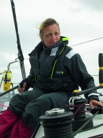
Single-handed ocean sailor Pip Hare has clocked up thousands of miles racing and cruising. Among her achievements are five solo transatlantics, including the OSTAR and two Mini Transat races. She also works full-time for the RNLI on sea safety and is Consulting Editor on Yachting World