
World and European Championship-winning professional navigator (and winner of the last Fastnet Race), Tom Cheney, on how to win on the new Rolex Fastnet Race course to Cherbourg
The 2021 edition of the Rolex Fastnet Race came with an interesting change. The finish line, having always previously been in Plymouth, is now in Cherbourg. Not only does this extend the race from 603 to 695 miles, but statistically this is likely to increase the amount of downwind sailing.
As a navigator, I find it important to break these longer races down into manageable chunks. I give myself a series of bullet points and prompts for each leg and make sure I know what the big risks/decisions are that’re coming up.
This also helps to identify the less intense sections of the race so that I can manage getting some rest. Here is a breakdown of the Fastnet race course in five sections:

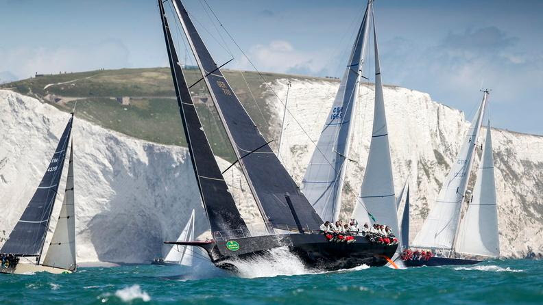
The fleet battles its way out of the Solent after the start of the 2021 Rolex Fastnet Race. Photo: Carlo Borlenghi
1 Exiting the Solent
When considering how to win the Fastnet Race is worth noting that the event is never won in the Solent, but it can easily be lost there. A record number of entries in this year’s 50th anniversary edition of the Royal Ocean Racing Club’s flagship race means there’ll likely be close to 500 yachts jostling at the start.
In the 2021 race, we witnessed our friends and sistership Dawn Treader being dismasted just minutes after the start due to a collision with a boat on port tack. With a fleet of boats vying for the strongest current in the centre of the channel, it’s vital to keep your wits about you, even when you’re on starboard tack.
Personally, I favour a cautious approach to the start line on these big offshore races. Obviously you don’t want to be hundreds of metres back from the line at the gun, but with the tide building and pushing you towards the line, there’s a huge penalty to be paid if you are over early.
Article continues below…
How to follow the 100th anniversary Rolex Fastnet Race 2025
The Fastnet Race in 2025 will be the a special 100th anniversary of the event and is set to be…

Fastnet Race 1979: Life and death decision – Matthew Sheahan’s story
At 0830 Tuesday 14 August 1979, aged 17, five minutes changed my life. Five minutes that, despite the stress of…
Positioning on the line, however, is key. The optimum point on the line for your start will depend on your place in the starting sequence and the wind direction. The ebb tide strengthens earliest inshore, just off Cowes Green, so you will often see boats pushing to be close in. The tricky part is successfully getting out again on port tack on a busy start. There are also some nice local left-hand shifts to be had around Egypt Point and Newtown Creek, where the wind funnels from the south.
Tidal strategy in the western Solent is fairly straightforward: aim to stay in the deep water channel. The port lateral mark, West Lepe, is a good first waypoint and the north cardinal, Sconce, is a good spot to aim at before the Hurst Narrows.
The final obstacle before heading out into the channel is the Shingles Bank. This sand bank moves around considerably year-to-year, so the very shallow bits (it dries at low water in places) are not always where they say they are on the chart. Most of the time you want to be sailing in the deep water on the south side of the bank. There are a few big red lateral marks that will serve as a good visual guide.
The other decision you need to make as you approach open water is where to position yourself against your competitors. Local land effects mean that the western Solent often ends up being a fairly true beat regardless of what the real gradient wind direction is a little further offshore. I always try to have in mind what true wind direction (TWD) I am expecting to see once we are out past the Needles. If you think TWD will be left of what you are seeing on the beat then you need to set up to be to the left of your competition (and vice versa). This will mean you end up with a nice gain when you get that inevitable shift.

Hurst Castle Light on Hurst Spit marks the western end of The Solent. Photo: Carlo Borlenghi
2 Needles to Lizard
This section of the racecourse is all about timing approaching the key tidal gates.
St Alban’s – Even in a very light airs start you would expect to be round St Alban’s Head with positive current. If you are close inshore, there is a nice tidal advantage to be had by making the most of the acceleration along St Alban’s Ledge, although the overfall symbols that you see on the chart are there for a reason!
Portland – The main deciding factor of your route along this 160-mile leg along the south coast will be the timings for whether or not you are going to make the tidal gate at Portland. In the days running up to the start of the race, you should be looking at the medium term weather forecasts and running some routing to work out the timings for your boat. Realistically you need to be confident that you will be west of the Bill seven hours after start time to justify being in close. If you think you are marginal on making the tidal gate then you need to be heading offshore. At its peak, you can experience 5 knots of current against you inshore, whereas five miles offshore there will only be 2 knots.
There is a passage through very close inshore, a reasonable eddy extends a long way north up the eastern approach to the Bill, but it involves being metres from the rocks once you get to the southernmost tip. I’d not recommend doing it on anything other than a flat, calm day with good visibility. I have made it work once, but it was not a relaxing experience.
Lyme Bay and Start Point – There are similar gains to be had further down the coast at Start Point, although the speed of the current there is not as extreme as at Portland. In my experience, the strategy in Lyme Bay (the bay before this headland) is more wind-based than worrying so much about the tide. If you have started the race in a classic British summer sea breeze, then these bays on the south coast can become big wind holes to be avoided at night. Lyme Bay in particular is often windless and difficult to navigate at night in the summer. My rule of thumb is to stay well away after dark.

Exclusion zones for the Lizard to Fastnet Rock leg of the race include the Land’s End, Scillies and Fastnet Traffic Separation Schemes
3 Lizard to Fastnet Rock
The modern Fastnet Race course includes some additional exclusion zones, areas that you cannot enter as a competitor without being disqualified. Three of these obstructions are the Lands’ End and Scillies Traffic Separation Schemes (TSS). These areas are busy shipping lanes, so you also need to be careful when approaching them. The three TSS obstructions around the Isles of Scilly will have a big impact on the route you can take from Land’s End to the Fastnet Rock. The Scillies are only a mark of the course on the way back from the rock, so you have a lot of options here: several routes through the middle, or north/south of all of the obstructions. Routes south and north both add several miles to the course.
The distance from the north-east point of the Land’s End TSS to the south-west point of the Scilly South TSS is over 50 miles. This is a massive amount of leverage if you are going upwind across the Irish Sea.
The distances involved in this decision mean you need to be deciding based on what you’re expecting to happen over the following six hours. A significant wind shift to the right or left is going to be a huge gain or loss relative to a boat that chose the opposite approach. In the 2021 Rolex Fastnet Race we left this decision very late, before diving north of the Land’s End TSS. It was a beat from Land’s End to the Fastnet Rock, but we ended up sailing downwind with a spinnaker up (against tide) to the top of the TSS so that we could be set up for a big right-hand shift.
If you are not expecting any large wind shifts, then generally new weather will be arriving from the west, so a good rule of thumb when crossing the Celtic Sea is to stay left of the rhumbline.

The Fastnet TSS must be left clear to port on approaching the Rock, and the same again when heading back south-east
4 Fastnet Rock to the isles of Scilly
Rounding the Fastnet Rock (and the Fastnet TSS) can be stressful as a navigator. Most of the roundings I can remember have either been in the dark or in thick fog. Combine this with having to avoid another TSS obstruction (you have to leave the Fastnet TSS to port on the way to the rock and again on the way back).
When skirting these separation schemes make sure you know where you are and how much margin you have between you and the invisible obstruction. Set yourself some safe waypoints; I usually place these a few hundred metres from the corners of the TSS. A useful reference on your computer is that 0.1 nautical miles is about 185m. Set yourself up with a display somewhere that shows you the cross track error (XTE) on the leg between these points. This number tells you how much room you have. Keep talking to the helm, give them a course to steer and don’t be afraid to update it if you think you are too close for comfort.
Generally the leg back to the Scillies is downwind, and often the wind at the Scillies is further south-west than when you round the rock. It’s easy to get caught out, headed and north of the islands. Now the finish is in Cherbourg there’s much less reason to be close in at Bishop Rock.

Rounding the famous Fastnet Rock and its landmark lighthouse in the Irish Sea. Photo: Rolex/Kurt Arrigo
5 Scillies to Cherbourg
This is where it gets interesting. With the new finish line in Cherbourg, there is an additional challenge in store on the final leg of the race. In the final 50 miles you have to pick a route past one final TSS and the infamous Alderney Race.
Alderney Race, known as Raz Blanchard by our friends across the Channel, experiences some of the strongest tidal currents in Europe. During the equinox the current can reach 12 knots at its peak. On a summer spring tide, you’re likely to see 5-6 knots of current.
Much like the tidal gate at Portland Bill, getting past Alderney and Cap De La Hague is all about timing. As soon as you are past the Scillies (hopefully with an up to date weather forecast), you need to be working out what time you will be approaching the Alderney Race. The Race is a spectacularly dangerous stretch of water and you should exercise extreme caution when sailing through or near it. In addition to the extreme tidal conditions, the north Normandy coast can be fickle wind-wise, particularly on summer mornings. This makes it even more crucial to have a good tidal strategy.

East-going flood tide
Best-case scenario is that you have strong east-going tide in the channel (north in the Race).
In this instance, you can sail the shortest course, south of the TSS and north of Alderney. The main thing to look out for in this situation is not to get pushed too far north as you cross the strongest tidal flow. The correct course to steer will feel very strange, your heading will be a long way right of the headland. You also need to bear in mind that the wind direction experienced on the water will be shifted towards the north because of the tidal vector. Anticipate the shift back as soon as you are back into the east-going tide.

West-going ebb tide
Worst case scenario: if you’re unlucky enough to be arriving with the full strength of the current against you, then you may need to consider a route to the north of the Casquets TSS. If reaching, this route adds 10 miles to the distance sailed (not the case if sailing VMG downwind) so it’s not always going to be a good idea. In light winds you need to be careful not to be pushed back west, into the TSS.

Slingshot effect
If you are arriving at around LW, just as the tide turns to go east in the English Channel (north in the Race), then you can take advantage of the strong north-going tide by leaving Alderney to port. This is a good option if you’re arriving a bit ahead of your original plan and are worried that the tide might be against you initially. At this point there’ll be less than 1 knot of current out in the Channel, but 2-3 knots going north through Alderney Race. You’ll also want to stay quite close in at Cap De La Hague (French mainland) to get the benefit of the strongest current on the mainland shore.

The winning Sunrise crew at the finish of the 2021 Rolex Fastnet Race. Photo: Paul Wyeth
Useful tools for the Fastnet Race
Navigation software
Broadly navigators fall into one of two camps: Expedition or Adrena. Both are very mature solutions, although not without their quirks.
An easy mistake to make is to blindly download a weather forecast, plug in a route and a polar table for your boat and just follow the route optimisation that it spits out. In reality these are all tools for exploring options, they’re not supposed to give you a definitive route to take.
Whichever tool you choose, make sure you’re familiar with it and get used to using it off the boat. Try routing one leg at a time, rather than looking too far ahead. Add additional waypoints into your leg to force you into corners and compare the times of the results. This will help you understand the sensitivity of the decisions you’re making. For example, you may not want to take the risk of sailing the long way round a TSS, exposing yourself to a big risk, if you realise that the reward is only a two minute theoretical gain.
Weather models
For the bigger picture I look at the GFS (American) and ECMWF (European) global models. These are independent forecasts that cover the whole planet and can give you a 10-day forecast, although levels of confidence drop quickly as soon as you’re more than a few days out. Global models are then used to initialise the higher resolution forecasts for smaller areas. These higher resolution models are also fed information about local terrain and recent observations or land and sea temperatures. This enables models like the AROME, from Meteo France, to do a really good job of predicting sea breezes that are driven by local thermal effects. These high resolution models are available as GRIB files from subscription services, including (but not limited to) Squid and PredictWind. Tidetech high resolution tidal models cover the whole course – a fantastic tool, but not cheap.
Internet onboard
A good internet connection allows you to get the latest weather information, competitor tracking information and real-time weather observations. Not all boats have the latest satellite systems, though luckily lots of the Fastnet course is covered by regular 4G mobile phone reception and it’s easy to get a cheap pay-as-you-go data system for your navstation, or even simply hotspot to your phone when you’re close to land. Whatever your setup, make sure that you’re familiar with how to use it.
 If you enjoyed this….
Yachting World is the world’s leading magazine for bluewater cruisers and offshore sailors. Every month we have inspirational adventures and practical features to help you realise your sailing dreams.Build your knowledge with a subscription delivered to your door. See our latest offers and save at least 30% off the cover price.