
Uncrowded and rich with wildlife, Newfoundland offers a lifetime’s worth of exploration. Tom Zydler reports
Two beluga whales flanked Frances B, our Mason 44, as we threaded out of Ingonish, on northern Cape Breton Island. Belugas don’t live in this area so this unexpected show was a symbolic beginning to a summer of surprises.
Frances B headed across Cabot Strait, vaguely pointing towards the south-west corner of Newfoundland. The plan was to circumnavigate the island whose coastline, including all bays, fjords and sounds, tops 10,000 miles. In view of weather patterns the whole operation had to run efficiently – we’d better be out of these waters by the end of September.
Now in July, and for the rest of the summer, south-west winds would prevail but come September depressions begin to slide from the Arctic bringing strong northerlies. Whether to go around clockwise or counterclockwise was the question.
 During a night of flopping in expiring puffs we decided on a counterclockwise route. At dawn the night fog lifted over a line of dark islets, with long, lazy swells foaming over sunken ledges. A couple of guys fishing in a dory by a red buoy waved cheerfully.
The town wharf in Isle aux Morts settlement now became our springboard to eastward exploration of the southern coast. The village has probably existed for five or more centuries. The Indians were first. Next came the seasonal waves of European fishermen. Catholic Europe craved cod. Merchants and shipowners grew wealthy, fisheries gradually became deadly efficient.
In 1992 the cod fisheries, the mainstay of Newfoundland’s life and economy, were closed. The cod were gone. Isle aux Morts, and scores of other ‘outports’ were nearly abandoned. It took the discovery of offshore oil to push Newfoundland towards economic recovery.
Article continues below…
Sailing Nova Scotia: Jagged coastline makes for a unique cruising experience
As soon as the sun began to disperse the fog that had settled at night over Pubnico Harbour we weighed…

Bear necessities: Cruising the Broughton islands on Canada’s Pacific coast
We left Dead Point at 0800 in a flat calm and entered Beware Passage – inauspicious names for cruising in…
Tales of old
A walk over a hill took us to the older harbour, tight but safe behind a fence of islets. Below a church on a hill the town museum welcomed visitors. Percy Billard led the tour, upstairs, downstairs, through rooms scarcely larger than a dollhouse’s, filled with scrapbooks preserving tales of perils at sea, wrecks, home-made furniture, spinning wheels, boat models, tools hewn from timber. The tiny structure had served as a family home, a school and a chapel depending on the need of the week.
For the next 300 miles, till the coast turns north at Cape Race, we had expected to blunder on through blinding fogs. Yet blue sky often won out. In the channel between the Ramea Islands the boat floated on Caribbean blue waters, rocks a few fathoms below clearly visible. Several impressive fjords cut into long stretches of this wild, roadless, sparsely inhabited coast.

Percy Billard leads a tour through a home preserved as a museum in Isle aux Morts
While steering through into Grey River, bright sunshine painted one range of hills a lively green. Looking ahead into the main run of the fjord revealed high battlements of colourful yet brutally naked rock. We chose to follow the greener walls into Southeast Arm and anchored off a shallow lagoon fed by mountain streams.
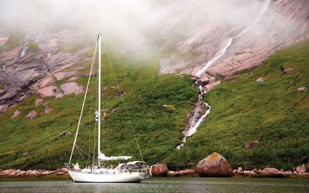
But a couple of days later La Hune Bay fjord reminded us why Newfoundland had been nicknamed ‘The Rock’. The dramatic, high rock walls rose into dark cloud, and waterfalls tumbled from above into Deadman’s Cove.
Most harbours with connections to the road system of Newfoundland have public wharves, often even floating docks with water and electricity. We enjoyed such comforts in Fortune, a harbour on Burin Peninsula and found in the small town propane, diesel, groceries, a restaurant serving fresh fish – all dear to a sailing visitor.
Also, it wasn’t all rock in Newfoundland after all; trails led into flower-scented forests and meadows along a river. Time went fast while we waited for good weather at the next important waypoint – the infamously foggy Cape St Mary’s.

Clear, cold waters and spectacular scenery are all part of the Newfoundland landscape
Sea birds numbers are declining worldwide but Cape St Mary’s on Avalon Peninsula has a colony of over 20,000 nesting gannets. The dawning sun threw long shadows of high land over the ocean when we arrived.
Despite the lazy swells of a calm sea the scene was frantic. Raucous bird calls and whiffs of guano drifted down the rock stacks. Overhead squadrons of gannets circled searching for schooling fish, and there were several whales and fishing boats doing the same at our level.
Now and then the surface boiled with gathering prey and gannets plummeted like rockets from a great heights. Fishermen revved up to get their nets down. Whales, fish, birds and fishermen in all northern waters depend on vast schools of capelin. The stocks of this small, sardine size fish exploded in 2018 and codfish, whales, birds and coastal people thrived.

A puffin in summer plumage brightens the skies near Bonavista
Soon after Cape St Mary’s the Avalon Peninsula turns north. With Ireland the nearest land 3,000 miles across the Atlantic, we expected the ocean to roll in gigantic swells. But no, the seas stayed down and visibility was good, just a bank of fog anchored farther offshore. It was a perfect time to hang around islands near Witless Bay.
Strings of puffins raced to sea and back, and flocks of fluffy white kittiwakes floated near Great Island. Row upon row of black and white murres and guillemots occupied Green Island’s cliff ridges. Every so often clouds of birds rose blurring the land.
Another surprise lurked a little farther north on this Avalon coast. Without help from a chart one could easily sail unaware by St John’s, the capital of Newfoundland, a city of over 100,000 hiding on the inner hills. The Narrows Cut, steep cliffs on each side, guarded by cannons, opens up on a landlocked port of trawlers, longliners and oil rig tenders.
Berth for the night
It must have been a challenge to enter in the days of sailing ships and today the challenge is finding a place to tie up a modest yacht. Forget the busy commercial wharves with titanic fenders and look for a long liner to raft against.
Heading north from Avalon Peninsula brought to light different aspects of coastal Newfoundland. While St John’s rushes on into modernity, in Bonavista, one of the oldest ports thrusting into the Atlantic from the north-eastern coast, people renovate the clapboard salt box homes from the late 18th and early 19th Century.

After leaving Bonavista, the Dutch yacht Maaike Saadet sails out into Blackhead Bay
Jerry Mouland, the Bonavista harbour master and talented professional photographer, pointed us towards a colony of puffins, a few miles from town. From a small headland we looked down onto a breeding roost 75m away. Puffins rocketed to and fro right by our heads. As we sat mesmerised, just before dark, a few unattached birds landed 5-10m from us to dig nesting burrows for the next season.
Leaving Frances B at a wharf of the Marine Interpretation Centre in the harbour of Seldom-Come-By allowed exploring Fogo Island. While at it I realised this island was a symbol of how the lives of Newfoundlanders have improved. The fisheries continue at reduced scale but continental Canadians have discovered Newfoundland.
So encouraged, local people now cherish their past of hardship and resilience through art and entrepreneurship. The strikingly modern structure of Fogo Island Inn crowns the shore cliffs at Joe Batt’s Arm. The very upscale resort is the brainchild of Zita Cobb, a native of the island who made a fortune in fibre optics. The avant-garde architect was Todd Saunders, another child of Fogo.

The settlement at Fogo Harbour
Treasured islands
West from Twillingate are waters of Notre Dame Bay, treasured for its islands, sounds, bays and passages. While we swung at anchor off Long Island a traditional wooden skiff approached. The man on board called to us: “Go around the corner to Beaumont Cove, totally protected bay, and come visit!”
The Flowers family use their summer house there when visiting from their home in Hopedale, Labrador, where Valerie, a Beaumont native and her Labrador husband teach. They took us walking over the island’s wild hills. Near a remote pond we saw small trees that bore deep incisions and a giant heap of twigs, all of it the work of a beaver.
The family is used to living off the land, and for supper they laid out ptarmigan stew and bannock. We had to leave in the morning, so we missed the next evening’s treat: boiled caribou lips. Island fare was becoming interesting. In Round Harbour, another remote bay shaded by high hills and cliffs, we received gifts of halibut and squid from the local longliner skippers.

The author at Frances B’s mast
On a walk along one hilly road we stumbled onto a display of large models of a variety of boats, sail and power that once worked these waters. Pat Skinner, a retired skipper and a shipwright, just couldn’t resist building a few more boats. He still fishes so we carried quite a few cod fillets back to our boat.
The massive Northern Peninsula stretched for miles across our westward course like a fat finger pointing directly at the Arctic. The charts and a map promised high lands conspicuously lacking any roads. An unspoiled wilderness awaited.
At first the approach to the grand fjord of Great Harbour Deep caused controversy. The raster chart display put the boat in the correct place but lacked any detail. The vector chart, a newer product and off by three quarters of a mile, had us climbing cliffs. However, the radar, our worn out paper charts and the old fashioned method of keeping our eyes open helped us all the way to the head of Soufflets Arm and through a squeeze by a gravel bar.

At anchor in Soufflet’s Arm of the Great Harbour Deep
The fertile, cold waters that wash this coast nourish great numbers of marine mammals. Whales seemed totally indifferent to our approach, and we saw dolphins too. Every few miles a slot in the cliffs marked another fjord like bay. The contrary current slowed progress and off Croc (also Croque) Harbour, Frances B headed in.
After some poking into the shoreline margins we slipped into Épine Cadoret creek. A couple of newer homes overlooked a classic outport scene: white crosses in a cemetery just above timber wharves, weather-worn, red-painted sheds teetering on the brink of collapse, and an old sloop wreck slanted on rocks.
We swore to return while sailing northward. After a visit at St Anthony Harbour, an important but charmless fishing vessel base, the fresh easterly propelled us to the end of the peninsula. The wind-reinforced current cannoned the boat through Quirpon Tickle, a mid-channel rock buoy and the shore flew by in a blur.
Fairer weather

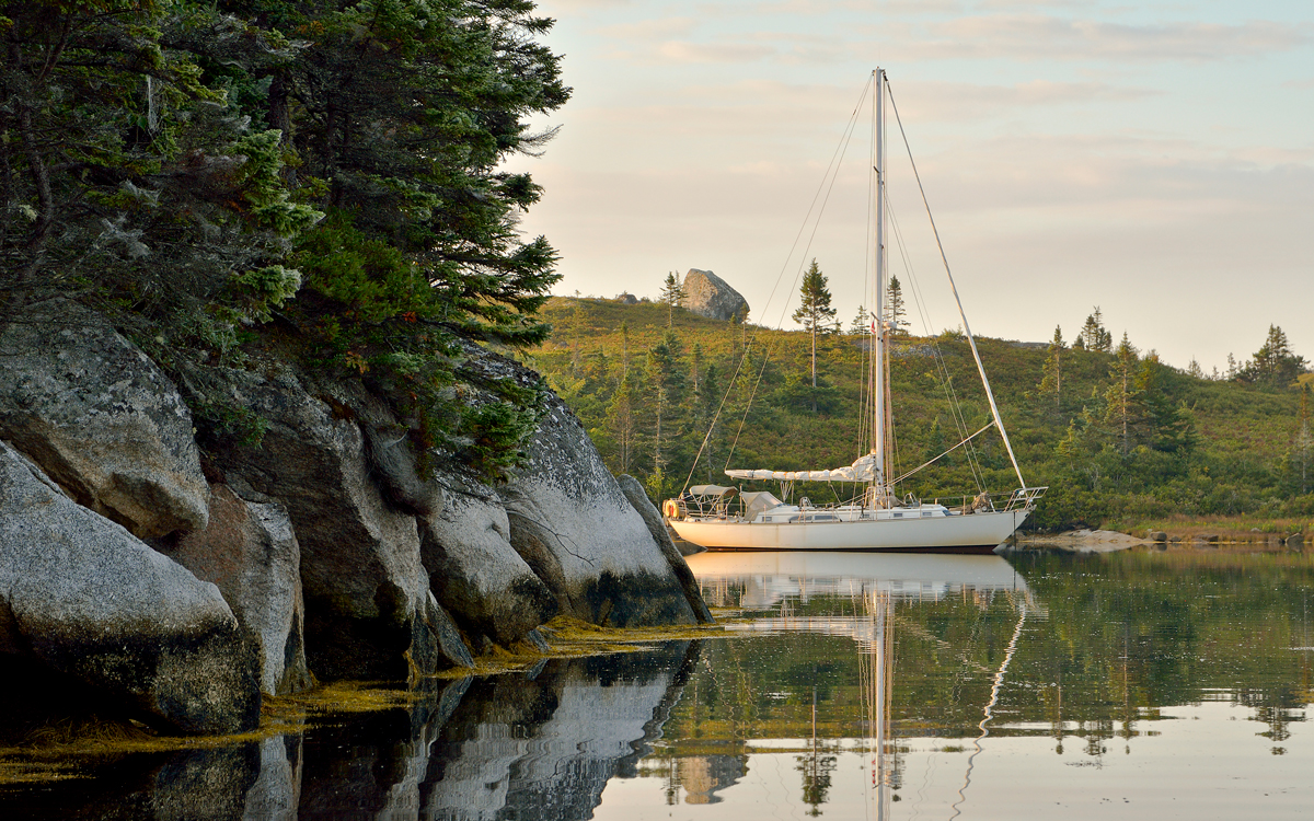
Frances B enjoying a calm day in Noddy Harbour, Bonne Bay, western Newfoundland
With the east wind in the Strait of Bell Isle the sea smoothed, visibility improved and the breeze hummed from low hills abeam. Thankful for the good spell, we hurried on southward; these waters turn challenging during the usual strong south-westerly. The wind backed to a light southerly next morning but by then the bow pointed into the slot leading to Port au Choix.
The shelter came at the right time. In the lee of high breakwaters the boat dozed at a floating dock while the rigging moaned in the gusty south-westerly – for seven days. During our enforced stop, we walked and walked, mostly out to the cliffs facing the sea, following a herd of caribou every day that sauntered down to the few plants at the water’s edge. We noticed the moose preferred a different shore backed by a forest of dwarf trees. They were less trusting and trotted away from us.
From Point Riche and Port aux Choix the western shore runs south. The mountains dominate the coast and embrace two deep branching fjords with land in shadows of dark rock walls. These heights do awful things to gale force winds. Twice in the past we had cowered as williwaws whipped up water spouts.
On calmer summer days exploring the Southeast Arm was a delight. At Woods Island, out of line of squalls, the shelter is good, and floating docks are available courtesy of Bay of Islands Yacht Club based in Corner Brook. The walks in the forests ashore lead to rings of bright yellow mushrooms, the best chanterelles this side of the Atlantic.
Days went by as we waited for weather to ease. Close to the end of September, late season at this latitude, we finally got a break. We had a run of 180 or so miles along a shoreline lacking really good ports and that took us to Cabot Strait. The forecast southerlies ahead of another low were late – our luck held.
We crossed all the way to Bras d’Or Lakes, the protected waters in the heart of Cape Breton Island and a worry-free waterway almost all the way to almost balmy Nova Scotia. It was hard to leave Newfoundland, an uncrowded island where people welcome visitors with sincere pleasure.
We lost count of the all the places we didn’t have time to explore. Really it would take more than a lifetime to see it all. But trying to would be fun.
About the author
 Tom Zydler is a marine author and photographer, who has written many articles and cruising guides. He and his wife Nancy sailed round the world via South America and Antarctica.