
Does the ‘green flash’ exist? Some swear they’ve seen it; others declare it’s the result of too much rum. Chris Tibbs gets to the bottom of the argument

Caribbean cruising is not complete without sundowners on a beach watching the sun slowly dip below the horizon. Invariably the conversation will turn to the ‘green flash’ and the group will be divided between those who swear they have seen it and the sceptics who believe it is more to do with the amount of rum that has been drunk.
There is a scientific basis for the green flash: it is the refraction of light and may be observed at sunset as the upper limb of the sun disappears. It may also be seen at sunrise as the upper limb of the sun rises.
At sunset and sunrise the light from the sun must pass through a thicker band of atmosphere and this thicker band bends the different wavelengths of the light by different amounts, with purple and blue bending the most and red the least.
There is a scientific basis for the green flash: it is the refraction of light and may be observed at sunset as the upper limb of the sun disappears
Blue light tends to be scattered by the atmosphere so little actually reaches us, therefore rather than seeing a blue light we see green light instead.
But this green is usually too faint to see with the human eye so we need some meteorological help. This is in the form of a temperature inversion or when the surface temperature is very warm.
With the correct conditions a quick flash of green can be spotted just as the sun disappears. It lasts for around a second, although in polar regions where the elevation of the sun changes very slowly, it has been reported to last for some minutes.

Matthew Fordham managed to capture this photo over the hills of the South Coast
Seeing the final segment of the sun as green is therefore not that uncommon and occasionally it can be more of a flash as green rays shoot up from the horizon. The green flash is therefore a combination of the physics of the atmosphere and the temperature profile from weather conditions.
The green flash does exist and is most often seen in tropical sailing areas looking at a clear horizon. The temperature inversion is typical of high pressure, and as it is cells of high pressure that drive the tradewinds, we can expect occasionally to see a green flash in these areas. Polar regions are also generally under the influence of high pressure.
Temperature inversions
The temperature through our atmosphere generally falls with height up to around 11km where we find the tropopause, and it is within this band that our weather occurs. However on occasions we have a temperature inversion, where at some point the temperature rises with height rather than falls.
This is most clearly seen at times of high pressure where the inversion restricts the development of cloud formation as it interferes with the vertical movement of air. If there is any cloud it is in the form of stratocumulus trapped under the inversion.
————————————————————————————-
High pressure sailing
 Although we get light wind near the centre of a high, there will be strong winds at the periphery. As high pressure tends to be slow-moving the wind speeds and direction will remain steady sometimes for days.
As the vertical movement of the air is restricted by a temperature inversion we can get strong bands of wind being funnelled near coasts. A good example of this is in the English Channel with an east-north-easterly wind where we get stronger wind bands than isobar spacing would suggest, particularly around headlands at night.
These are sometimes referred to as coastal jets and can give a large increase in wind.
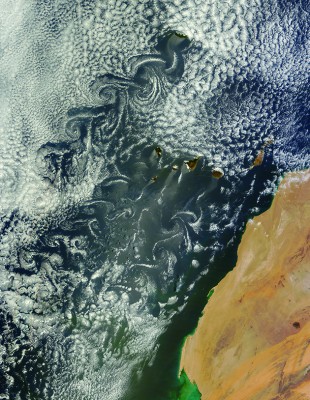
Further afield in the Canary Islands, you get strong acceleration zones around the islands that can increase the wind speed significantly in the space of a few hundred metres being caused by the shape of the land along with a temperature inversion from high pressure.
The fascinating satellite image of the Canary Isalands (above) shows stratocumulus clouds and the effect the islands have on the wind flow, giving Von Karman vortices. These are caused by high pressure combined with a temperature inversion

Chris Tibbs is a meteorologist and weather router, as well as a professional sailor and navigator, forecasting for Olympic teams and the ARC rally. He is currently on his own circumnavigation with his wife, Helen. His series of Weather Briefings can be seen here
See also:
Chris Tibbs prepares his own boat for an Atlantic crossing
The best route for an Atlantic crossing
Taking the northerly route across the Atlantic
Offshore weather planning: options for receiving weather data at sea
as well as Chris Tibbs’s series of Weather Briefings