
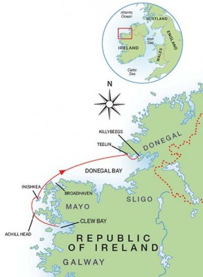
At the end of summer, Daria Blackwell and her husband cruised up the wild and windy Atlantic coast of Ireland to Donegal and found it the best cruise of the season

lt’s the last sail of the season. The harbours are empty save for a few stragglers in denial of a season that never was, hoping to catch a final magical day out. The days are short and the chill instant as the sun dips below the horizon.
The wild Atlantic coast of Ireland is about as challenging a place to sail as you could conjure up. But in the autumn, on occasion, the weather surprises, the shoreline is vivid, the light takes on a moody, silvery quality, nature delivers spectacular displays that we are actually awake to see, and the wildlife takes over.
We needed to haul Aleria this year for several maintenance chores and a bottom paint. The best option was to sail north to Killybegs in Donegal, one of the most important fishing ports in Europe. Our only slight concern was the weather in this remote stretch of water.

Photo: Vicki Nokomis
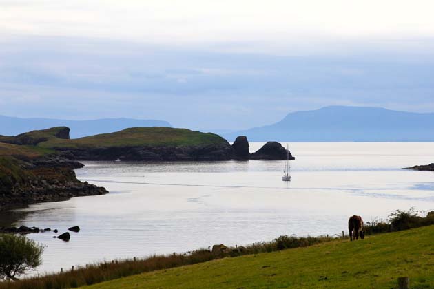
On a beautiful morning mid-October, we departed from Clew Bay on the outgoing tide. High tide was at 0800 and we needed to leave early to make the 50-mile trip to the Inishkeas. The sky turned an amazing purple with the morning sunrise breaking through heavily overcast skies. The weather had been miserable all summer, but October proved spectacular: very little rain, not too windy and not too cold.
We hoisted the sails and made our way out of Clew Bay against a flat grey backdrop. The wind was north-easterly instead of the forecast south-easterly, which was fine on a heading of due west, but not so fine when we turned north-east around the corner at Achill Head.
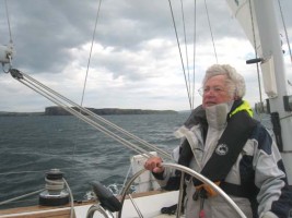
I was at the helm until I became chilled and turned it over to Alex. He soon started the engine and began motor sailing around Achill while I went below to warm up. I started feeling a bit queasy, which is unusual for me. Suddenly, a wave of nausea overtook me. I ran up on deck.
Never seen more confused seas
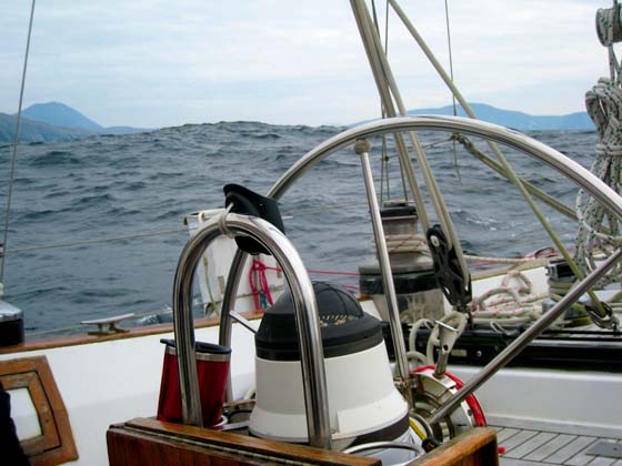
As I looked around I was horrified at the sea state. It had been quite calm inside the bay. There was a large swell coming from the west, a second from the south, and a light wind whipping things around from the north-east.
I have never seen more confused seas. The water was undulating every which way as we rode up, up, up and down, down, down on the big swell. Worse still, the swell was bouncing off the cliffs of Achill, which it always does, producing an easterly cross swell.
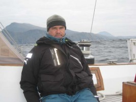
This little stretch is one of the most uncomfortable and treacherous places I’ve ever sailed. Alex was turning green too, so we took seasickness tablets and let the autopilot do its job. Lunch consisted of a granola bar, a banana and some yoghurt, all I could manage to prepare below.
A side benefit of heading north was experiencing the stunning coasts of counties Mayo and Donegal, which have the tallest accessible sea cliffs in Europe. It may be uncomfortable at times, but it is dramatic. At this time of year the sunrises and sunsets are awe-inspiring. As we anchored in the protected waters off deserted Inishkea South, the skies turned blue and the sun shone, changing the mood dramatically.
We discovered that the barnacle geese, thousands upon thousands of them, had just returned from their Arctic breeding grounds. We photographed them alighting over Inishkea South, but decided we were too tired to go ashore.
 We would stay a second night to spend the day on Inishkea North the following day. In fact, we were so exhausted after a day of being knocked around in the washing machine seas, that we had dinner, read a few pages and promptly fell asleep.
Hiking after the geese
In the morning, a breathtaking sunrise lit the sky in crimson and orange fire. We donned hiking boots and prepared cameras and a picnic lunch for a field trip. We launched the dinghy and motored to the beach, landing just as a small trawler came in towing a curragh. The skipper anchored his boat and took the curragh ashore with all manner of construction gear. He was in the process of restoring one of the abandoned cottages.
We tried to be very quiet as we walked across the middle of the island. We were hoping to come across barnacle geese grazing on the machair fields and we didn’t want to startle them. The first we saw of them was on a ridge in the distance.
We made our way over, crouching low along ancient stone walls to remain unobtrusive. Suddenly, a huge flock lifted off from a field on the other side of the ridge. As they flew over, the flock on the ridge lifted off and joined them. They went round in a circle over the island and settled in a new field not far away. I estimated there were about 1,000 geese in that flock.
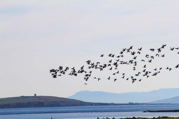
We saw a second and a third flock, followed later on by a fourth – our estimate for the day on the North Island alone was about 3,500 geese. We’d never seen so many birds in one place at one time.
At a sandy inlet surrounded by a rocky shore we heard a seal lamenting, but could not spot him until he slid into the water and swam out. A grey heron stalked stranded fish and crabs left behind by the outgoing tide. Tiny sandpipers flitted across the shore as a pair of curlew called overhead.
We stopped to photograph some of the remarkable archaeological remains of prehistoric, early Christian, Norse and more recent settlements. Then the perfect spot presented itself for lunch with soft raised seating facing a stony promontory leading out to sea. The sun was warm on our backs as we feasted on sandwiches, fruit and water.
A very fine day
We managed to walk the circumference of the entire island despite the soles of my hiking boots separating from the uppers. I tied the boots together with bits of rope strewn across the island by ferocious storms. All in all it was a very fine day.
The tide had not yet come in so we took off our shoes and rolled up our trousers. The water was surprisingly warm. We carried the dinghy to the beach and pushed it out just beyond the swell. A kayaker landed on Inishkea South where he had a tent pitched in one of the abandoned homes. Soon after that the light show began as sunset brought the day to an end with a brilliant display. The night was amazingly clear, with stars visible in the blackness of a deserted island.

Sheep grazing around a ruined house on an Island on Clew Bay
The next morning, we left the anchorage in the Inishkeas thinking we would stop in Broadhaven or Killala for the night. But then we had the brilliant idea of pushing to get to Teelin and having another day off to visit Slieve League. The seas had calmed, but there wasn’t enough wind for Aleria, so we motor sailed up the Mayo coast.
Quick calculations told us we’d be coming into Teelin after dark. That’s the drawback of sailing at this time of year. If our guess about the incoming tide giving us a push proved correct, we’d be in around 2000. We’ve been there before and know the straightforward approach and the spacious anchorage. We decided to go for it and revved up the RPMs on the diesel.
Feeding frenzy
Suddenly, there were gannets flying in from all directions. Then we spotted the reason. There was a feeding frenzy underway a short distance away. We could see the gannets dropping out of the sky from high above to snatch their unsuspecting prey. How they got the word out to all their friends remains a mystery.
As we turned the corner into Donegal Bay, whatever wind we had was, of course, on the nose. Once again, we dropped the sails and motored. Travelling at about 7.5 knots we were making good progress and steadily increasing speed with the incoming tide. I was just thinking that this would be a really great trip if we saw whales or dolphins, or even a basking shark, when out of the corner of my eye I caught a splash. Dolphins!
Our cameras snapped as they made a beeline towards us. It was a pod of eight common dolphins now riding our bow wake. We howled like children again. They stayed with us for quite some time, then frolicked away.
The sun set dramatically behind us as we headed north-east toward Teelin harbour. With GPS, chart plotter and AIS to assist us, there really wasn’t much to worry about, especially on a calm night at this time of year. We did keep a close watch out for fishing boats heading into or out of Killybegs.
As we neared the entrance, the street lights around the harbour shone down on the water. With my binoculars at the bow I could make out every boat and every mooring on the surface. The anchorage was wide open. We dropped anchor and tidied up just enough.

Boats moored beside Teelin Pier. Photo: Alamy
It was a very quiet night in beautiful Teelin harbour – no swell, little wind. In the morning, we launched the dinghy and went ashore.
The huge pier at the fish processing plant had a few boats tied up, but the harbour was otherwise deserted. Teelin was one of the most important fishing ports in centuries past, in its day processing even more fish than Killybegs. We tied up to the end of the pier where the ladder was convenient and the likelihood of our little boat obstructing someone was slim and walked to the village.
Slieve League cliffs
Teelin village is about three-quarters of a mile from the harbour in the shadow of the spectacular Slieve League cliffs, the highest in Europe. The Rusty Mackerel pub was closed mid-day, but it’s a good choice for a pint and an evening meal. Once owned by a member of one of Ireland’s most famous folk acts, Altan, it is now owned by British publicans. Indeed much of the village consists of new homes with British plates on the cars in the driveways – not surprising as it’s quite close to Northern Ireland. Yet that warm Donegal welcome still abounds.

Slieve League sea cliffs, Donegal Bay. Photo: Alamy
Surprisingly, there is a large new parking lot with craft shop and restaurant on the road leading to Slieve League. Ti Linn offers cafeteria-style food and displays beautiful local knitwear and goods. A bus stop has been added to provide a shuttle service to the upper parking lots with a new tourist office near the top of the cliffs. It is about 4km from the village to the top, mostly along a well-travelled road. They are clearly expecting large crowds. If you can, go now before it becomes a spectacle along the Wild Atlantic Way.
There are actually two paths. The one we chose, the Pilgrim’s Path, starts in Teelin from where walkers can slowly climb to the church ruins and holy well on the eastern summit of Slieve League. A second more treacherous path along One Man’s Pass at the very ridge of the cliffs is severely eroded. Walkers are asked to avoid that route until repairs can be made. It’s just wide enough for one pair of feet with precipices either side. Not for us.
Lighting was surreal
We walked up, way up, from the harbour to a point high on the cliffs. The views over Donegal Bay were spectacular. The lighting was at times surreal. There are spots for picnicking, a Napoleonic Tower, birds and animals grazing. We had the benefit of having sailed along the cliffs on our last visit. This is a very different point of view and well worth the trip.
We felt blessed, until we realised we had all that way to go back, most of it downhill, thankfully. But by the time we reached the harbour we were spent, and it was only 1500. Nevertheless, we pulled up anchor and made our way to Killybegs. We were scheduled for lift-out at 1000 the following morning, at precisely high tide.
From Teelin to Killybegs is a short passage – about ten nautical miles. The approach is straightforward, the coastline interesting. The weather was co-operating. The lighthouse on Rotten Island appeared where expected and we turned to port on the approach.
We nosed around the deep natural harbour surrounded by hills, then decided to anchor overnight across from the town in a peaceful deep water anchorage in Walker’s Bay. It is sheltered, out of the way of ship’s traffic – the big fishing vessels go out at all hours – and with great views of the town, the ships and the sunset.
Haul out
Morning came and it was time to go. The slings at Mooney Boats were lowered into the water on the high tide. The foreman, Darron, was there to help us. He had his remote control keyboard attached to him like an appendage. At the appointed time we entered the well below the travel hoist bow first.

Killybegs. Photo: Alamy
Unfortunately the forestay wouldn’t allow us to get in far enough to position the slings correctly. So out again, now trying to back in. Aleria doesn’t reverse very well – at all. Using the prop walk we spun her about. Then using docklines we were able to spring in and align perfectly before the tide went out. Phew!
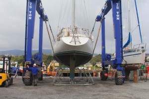 The 75-ton travel hoist did the job just fine. The facilities are top notch and the staff here couldn’t be nicer or more professional. They have a machine shop, a canteen and a chandlery. There is everything you might want for a yacht and supplies for huge ships alongside.
Although fishing is the main business at Killybegs, they are looking to attract more yachts in the future. There is a new marina planned for the inner harbour. Fortunately for us, Aleria has found a new home for the winter.
It was our best cruise of the summer.
Daria Blackwell is a USCG licensed captain who has crossed the Atlantic with her husband Alex aboard their 57ft Bowman ketch Aleria. Co-authors of Cruising the Wild Atlantic Way and Happy Hooking – The Art of Anchoring, they now live in Westport, Ireland.